• Skip to primary navigation
  • Skip to main content
  • Skip to primary sidebar

Have Media Will Travel

A blog about outdoor adventure, family travel, national parks, media, technology, marketing, fitness and me.

  • Travel & Tourism
  • Family
  • Fitness
  • Frontier Life
  • National Parks
  • Life and Leadership
    • Life Coaching
    • Epic Adventure
    • Leadership
    • Keynote Presenting

epic hikes

Teton Crest Epic Anniversary Day Hike – 24 miles for 24 years together

August 18, 2016 by Shelli

Howdy!
Howdy!

Some years ago, my husband, Jerry, and I had the idea to embark on an “epic anniversary day hike.” Every year, around our wedding anniversary, on a single day we’ll hike one mile for every year of marriage. Over the years, we have enjoyed some amazing, inspiring, fun and unforgettable anniversary day hikes.

On Aug. 22, Jerry and I will celebrate our 24th wedding anniversary. So this year’s annual anniversary epic hike would need to be, you guessed it, 24 miles.

Go ahead and say it. I know what you’re thinking. What about our 50th anniversary? Or our 40th – or 35th or 30th for that matter? I had to get a calculator out to learn that when we celebrate our 50th, I’ll be 74, and Jerry will be almost 80! (One friend joked that our plan to hike a mile for every year could end up being an “incentive for divorce.” LOL. I don’t think so, but I do think we’ll get more creative.)

But I digress. This is a blog post about our 24th Anniversary Epic day hike, and it’s a good one…

For some time now, we have wanted to hike the famous Teton Crest Trail. The Teton Crest Trail’s full route is about 40 miles long, and extends from Phillips Pass, on the border of Bridger Teton and Caribou-Targhee National Forests, to String Lake in Grand Teton National Park. 

Backpacker Magazine calls the Teton Crest Trail one of the “Best Hikes Ever,” with “mesmerizing and constant views of jagged peaks.” I consulted with my good friend, and fellow adventurer, Michael Lanza, about an “approximately 24-mile portion” of the Teton Crest Trail that we were hoping to hike. He gave me some tips, and as usual, Michael’s advice turned out to be stellar. (Thank you Michael!)

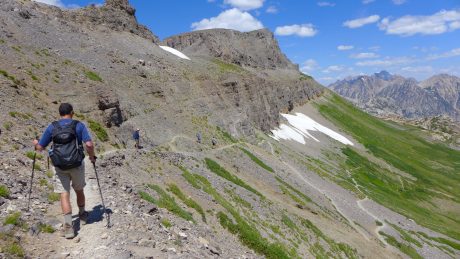
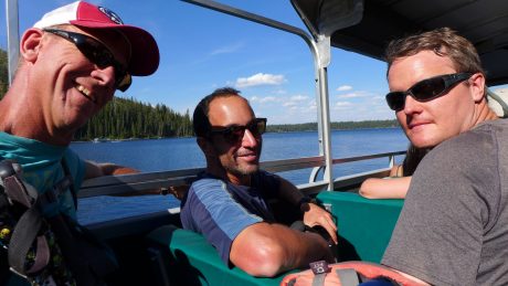
We would start at Death Canyon Trailhead, and hike almost 4 miles to the Death Canyon Patrol Cabin, at which point we’d turn onto the Static Divide Trail. We determined in advance that we’d definitely take a little extra time to scramble to the top of Static Peak, and after that, we’d continue through Alaska Basin and to Sunset Lake, before ascending Hurricane Pass. From Hurricane Pass, we’d descend through the South Fork of Cascade Canyon, before returning by way of Jenny Lake boat shuttle to Jenny Lake for a pickup vehicle, and hopefully some cold beers.

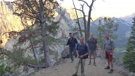
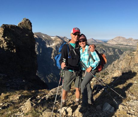
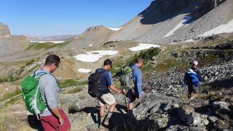
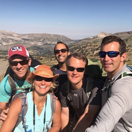
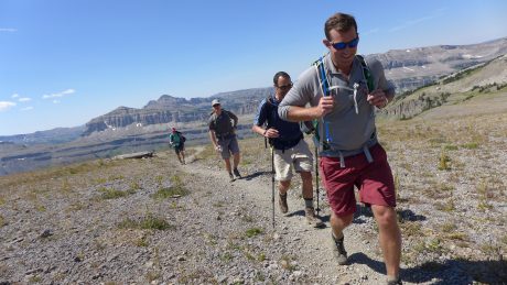
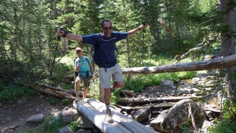
Normally we do our hike around our Aug. 22 anniversary, but this year two of our three sons start school on that day. And besides, some dear friends of ours, Alan and Marie Wexler, and their daughter, Margot, would be visiting their home in Jackson Hole earlier in the month, so Jerry and I decided on Aug. 13 for the big hike. We invited Alan, and were looking forward to celebrating our anniversary on the trail with him. (I had shared an Epic adventure with Alan in 2014, and I was looking forward to sharing the trail with him again.) Soon after, Alan invited one of his friends, Andrew, who was visiting from California, and Andrew invited one of his friends, Allen, who was visiting from Big Sky, MT. These guys were all great company, and Jerry and I made a couple of new friends, and will recall fondly the wonderful time we shared with these guys when we recall this Anniversary epic hike.

I think the best way to share about this hike is to show you photos and some video. But before I do that, my final words are these: We have been on many jaw-dropping, inspiring and epic trails over the years. After all, our backyard is the Wind River Range of Wyoming, and we’ve enjoyed countless unforgettable and spectacular hikes in our favorite mountains. Yet I am here to tell you, and hopefully show you, that we concur with Backpacker Magazine. The Teton Crest Trail is indeed one of “Best Hikes Ever.”

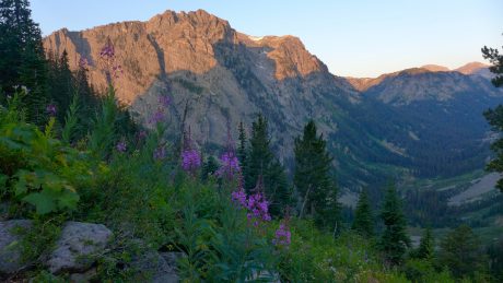
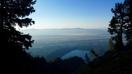
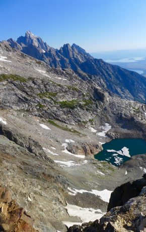
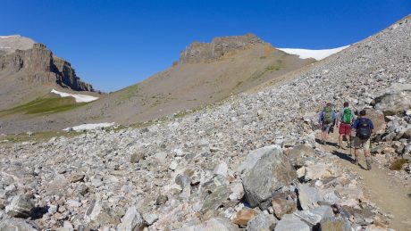
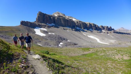
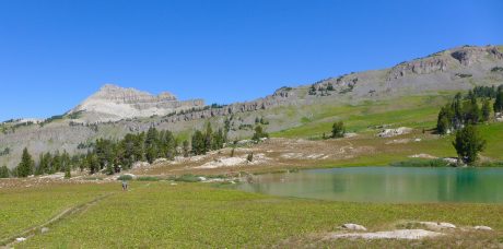
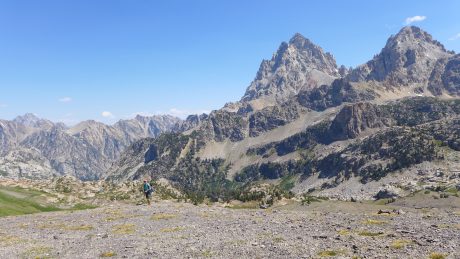
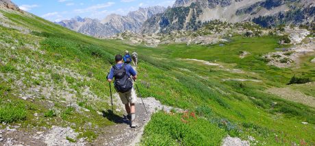
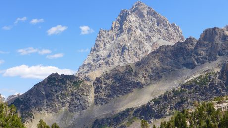
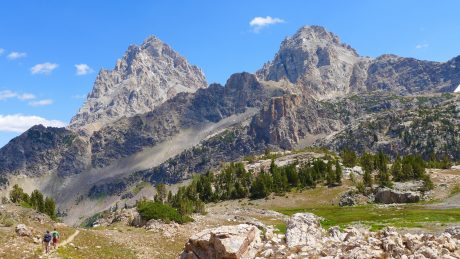
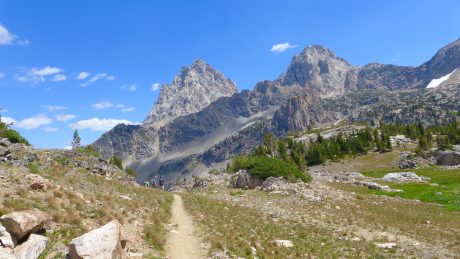
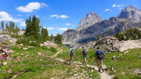
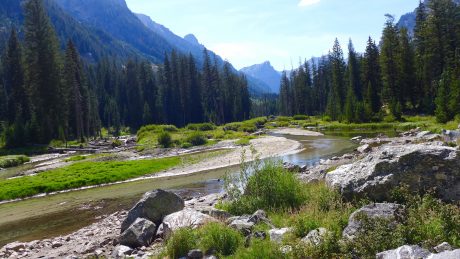
We had challenge: 6,300′ of elevation gain. We had unbelievable scenery. After hiking up switchbacks surrounded by tall granite mountains with alpenglow on their tops, and fireweed in the foreground, we crossed over a ridge and were rewarded with a stunning view of Phelps Lake, the Snake River, and the Gros Ventre Mountains below. Then we started across Static Divide, including a quick scramble to Static Peak’s top, from which we could spy a turquoise lake with ice still on it, and a unique perspective of the Grand Teton in a distance. By the way, I think Static Divide gets its name from the effect of lightning. You wouldn’t want to hike across Static Divide in lightning, that is for sure. Thankfully, during our hike, we had the opposite – a clear and blue sky.

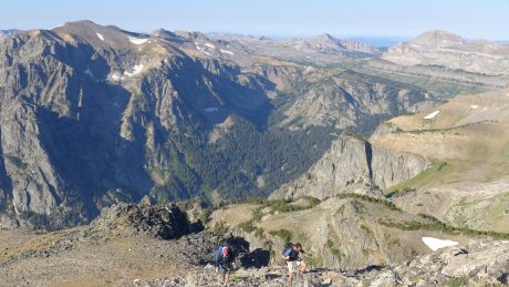
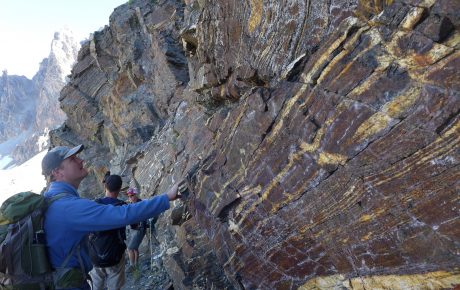
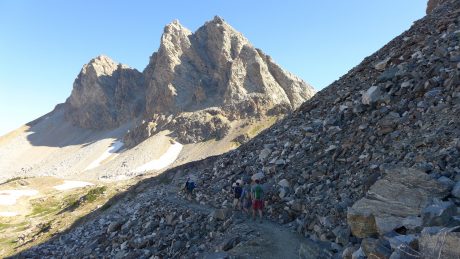
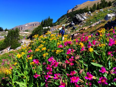
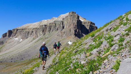
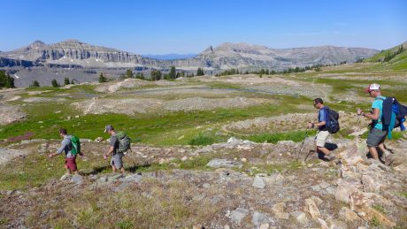
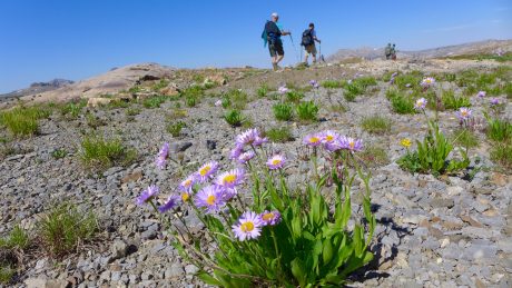
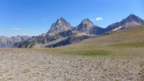
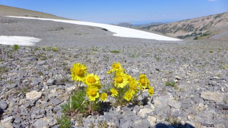
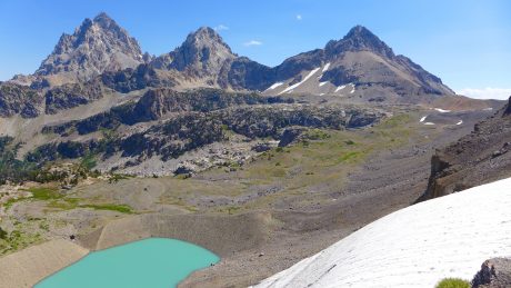
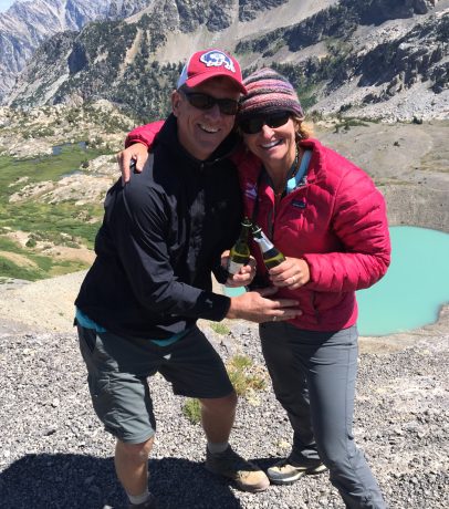
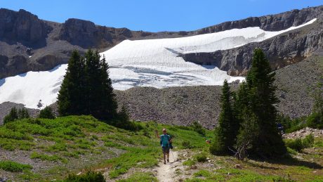
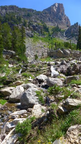
Then we hiked through some really cool, and very old rock, fields of a bazillion wildflowers of every color, and around the impressive Buck Mountain. We hiked through long stretches at high altitudes, in country that was huge and expansive. After enjoying some miles in the spectacular Alaska Basin, we reached Sunset Lake, which is striking and emerald green in color. We then hiked up Hurricane Pass, where we saw a glacier, and hiked around the back of the Grand Teton – enjoyed some champagne and an anniversary toast – before hiking our final miles on a trail that parallels beautiful cascades of water through the aptly-named Cascade Canyon.

Here are photos and some video:

Flowers and granite and alpenglow.
On the way up, up, up.
At 6.5 miles in, this view of Phelps Lake, the Snake River and the Gros Ventre Mountains.
Alan and Jerry, climbing Static Peak.
View from the top of Static Peak.
Jerry and I.
Jerry and I.
Cool rock.
Cool rock.
Hiking toward and around Buck Mountain.
Alan, and wildflowers.
Hiking in big country.
The scenery was expansive, and well, staggering.
Hiking by more flowers.
Group selfie at Buck Mountain Pass.
Heading into Alaska Basin.
Alaska Basin.
Alaska Basin.
More flowers. Alaska Basin.
Sunset Lake, and Hurricane Pass in the background.
Almost to the top of Hurricane Pass.
Hurricane Pass, and the "back" of the Tetons.
Hurricane Pass, and the “back” of the Tetons.
Flowers and snow.
Flowers and snow.
Jerry, looking tiny on the expanse that is Hurricane Pass.
Schoolroom Glacier and Lake, and the back of the Tetons.
Cheers to 24 years! Champagne toast at Hurricane Pass.
Starting the descent.
Alan and Jerry, leading us to greener pastures... :)
Alan and Jerry, leading us to greener pastures… 🙂
Looking back at Jerry and the pass above and behind that we were just on.
A "Grand" view.
A “Grand” view.
Not quite like horses to the barn, but it was all downhill from here...
Not quite like horses to the barn, but it was all downhill from here…
Not quite like horses to the barn, but it was all downhill from here...
Not quite like horses to the barn, but it was all downhill from here…
Our friends, leading us down.
Cascades in the south fork of Cascade Canyon.
Alan, crossing a raging river.
Lush terrain near the end of our hike.
Jerry, Alan and Andrew, on a slow boat across Jenny Lake, with dreams of cold beers...
Jerry, Alan and Andrew, on a slow boat across Jenny Lake, with dreams of cold beers…

Filed Under: Family, Fitness, Frontier Life, National Parks, Travel & Tourism Tagged With: alaska basin, cascade canyon, epic, epic adventure, epic hikes, grand teton, hurricane pass, jackson hole, shelli johnson, static divide, teton crest trail, wyoming, yourepifelife.com

Wind River Peak in a Day

July 5, 2012 by Shelli

Greetings. We were already 7 miles in when the sun rose.

NOTE: I know this is a long post. It was a long hike. 🙂 If you’re interested in hiking and climbing Wind River Peak, you’ll find key information in this blog. If you’re not interested in details, etc., I hope you’ll at least enjoy the photos and video at bottom. Or, here’s a 7-minute video blog of the adventure.

As a gift for my 44th birthday, my husband, Jerry, agreed to join me in hiking in and climbing Wind River Peak in a day. We had climbed it before — back in 1998 — during an extended backcountry trip we made with rented llamas, who carried our loads. Wind River was our first Wind River mountain to climb, a good one at that. Wind River Peak stands 13,192 feet tall, and is the tallest mountain in the southern Wind River Range of Wyoming.

The mountain is a massive and beautiful mountain, one that stands out from the southern half of the range. We can see the snowy, rounded peak from many of our favorite “back yard” locations.

Wind River Peak. (Photographed from Frye Lake on a different outing)

The last time Jerry and I climbed it, we ascended Wind River Peak’s south slopes, via Tayo and upper Tayo lakes. On this adventure, we would ascend its northeast ridge, above the Deep Creek and Ice Creek lakes region.

Our alarm went off at 2 a. m., which even for us early birds, was dizzying. It was more like the middle of the night than the early morning. But our insanity when we had set the alarm was rationalized by our desire to allow ourselves the biggest window of opportunity to accomplish the objective. We were going to be on a tight timeline because we wanted to make it back to Lander in time for our 10-year-old son’s last baseball game, which also happened to be a championship game, scheduled for 7:15 p.m.

We headed to Worthen Reservoir to find the trailhead, a 40-minute drive from Lander. With headlamps on and under a starry sky, we started hiking at around 3:45 a. m. I don’t mind hiking in the dark, but I prefer doing it pre-sunrise, rather than post-sunset. I like being far into the wilderness when the day is greeted by the first light of the sun.

We hiked three miles to Sheep Bridge, basically from 8,500′ to 9,000′ and back down to about 8,500′ again. As we made our way through the dark and quiet forest, the cool air was full and thick of the smell of a campfire. A fire (known as the Fontenelle Fire) was, and is burning, in southwest Wyoming, just over the range from us. The evening prior, Lander was in the thick of its smoke. We had been concerned that our hike might be smoky and that the peak may be a No Go today as a result of thick smoke. Fortunately the smell was from the smoke that had settled in the forest during the night and, by all indications, a stellar, bluebird day was ahead.

After arriving at Sheep Bridge, we joined the Middle Fork Trail and hiked up, and alongside the Middle Fork of the Popo Agie River for about three miles before approaching Three Forks Park. Here, we stayed right and started up the Pinto Park Trail, which eventually leads to Pinto Park and the North Fork of the Popo Agie.

On this day, the sun began lighting up the wilderness — at least enough for us to turn off our headlamps — at around 5 am. Soon after, at exactly 5:03 a.m., something curious happened. Right at that very moment, we heard birds chirping and singing. Until that moment, except for our huffing and puffing, it had been totally quiet. Then, we watched a small herd of elk emerge about 100 feet in front of us, to our right. Like I said, the day was going to be a good one. 🙂

We reached, and took a left, on the Deep Creek Lakes Cutoff Trail. Per our GPS, we had hiked 10 miles. After starting up the Cutoff Trail we hiked near Lake 10,054′, where we paused to watch several fish jumping and cutting through the otherwise smooth-as-glass water. We hiked for 2.3 miles before reaching the first Deep Creek lake, situated at 10,500′ elevation. Our GPS indicated we had traveled about 12.5 miles, and it was only 7:40 a.m. So far so good.

Steve Bechtel, my friend, and author of Cirque of the Towers & Deep Lake. A Select Guide to the Wind Rivers’ Best Rock Climbing, had provided information for us the day before about following “The Ramp” up Wind River Peak. We hiked another half mile or so beyond the first Deep Creek Lake before spying a trail to our right. Unfortunately I suggested we ignore that trail and keep hiking, thinking we weren’t to the ramp’s base yet. Oops. As we hiked toward Ice Creek lakes, it became obvious we (I) had made the wrong decision. So we backtracked a half-mile and picked up the trail and headed (seemingly straight) up. Nothing like making an epic day hike even longer, right?

After crossing over a little snow and a boulder field, we found ourselves on the broad ridge that separates Ice Creek and Deep Creek lakes that provides a half-mile-wide “ramp.” Once at the bottom of the ramp, we set our sights on a clump of rocks to the right of Chimney Rock and started up. Wildflowers were everywhere, growing up out of the alpine tundra and gravelly terrain. At times we hiked on tundra, others over rocks and boulders and at others, through snow.

The highlight of this route to Wind River’s summit is the almost-constant view you’re afforded of Little El Capitan, which, as its name suggests, features a massive and sheer wall, along with a notch known as “Surveyor’s Notch.” Little El Capitan is the fourth-tallest mountain in the southern Wind River Range. The sight of this wall is so astounding that we stood and looked at it, our jaws dropping, for quite some time.

At this point, midway up Wind River Peak, we were sucking air. We have climbed peaks before, this one included, so we were not strangers to thinner air. But doggone it anyway. On the upside, although there was a bit of a haze below us, in the direction we had come, we still had clear and bright blue sky around us on Wind River. The views that unfolded below us and around us were nothing short of spectacular.

Soon we reached the first of several snow fields. The snow was only knee-deep in most places and melting fast. Still, we were lucky enough that for most of the snow travel during our ascent we could walk on top of the snow.

Reaching summits takes a while. Especially Wind River Peak’s. The approach is a long haul to get to the base of the mountain, and then it’s a 3.5-mile hike to its top. I think as we were finally approaching the top of Wind River, my husband was wishing I had asked for expensive jewelry for my birthday instead of this epic hike.

Finally, when our GPS indicated we had only 92 vertical feet left to go, we got a surge of energy and soon reached the rock field that is the top of Wind River Peak. We made our way across it and climbed onto the pile of rocks marking the high point.

The views were as we remembered — epic.

We enjoyed a quick lunch break and I captured some photos and video before our time at the summit was up. We remembered that the summit is only the halfway point and we had a long way to go to make it home in time for our son’s baseball game.

Due to our missing the trail up we had logged an extra mile or so. Our GPS indicated we had hiked 17 miles once we reached the summit. And, at least in this case, downhill doesn’t mean easy. Going down is not easier than going up. It’s just that it’s different; it’s more about caution than effort, and our legs were tired.

We started down. Suddenly, Jerry, with much exuberance, exclaimed: “There’s a person!” I looked and spied a person not very far from us, ascending the peak. And then, Jerry yelled “There’s a whole bunch of ’em!” Turns out a NOLS course was summiting. These were the only hikers we’d see the entire day. Even though Jerry and I both love solitude, it was nice to see other human beings. 🙂 After a short visit with one of the instructors and some of the students, we continued.

When we hit the first snow field, our legs sank all the way down to our thighs. The snow was melting fast and it would be a little treacherous descending a couple of the snow fields. But on the final one, the most vertical of the snow fields, we enjoyed a long glissade. Standing on the summit with my better half was my favorite part of the day, but the glissade was a high second. It was a blast!

We got down Wind River much quicker than we got up it and before we knew it we were back on the trail. We still had 13-plus miles to go and not very many hours until game-time.

Finally, at Sheep Bridge, and only after enduring the 600-foot uphill slog it is known for, it was like horses to the barn. We made it back to Lander and to Hayden’s game right at the start of the game. As we arrived to the baseball diamond, we looked up and saw my parents, the boys’ babysitter, and our other two sons in the bleachers. At the top of the bleachers. I considered if I had another 8 steps in me. 🙂 And of course, I did.

What a hike and what a day! Once again it has been confirmed that anything’s possible if you’re willing to get up early in the morning, and, oh how I love my back yard.

By the way, when I’m not hiking — and sometimes when I am — I am a life and leadership coach and consultant. Check out EPIC LIFE, my coaching business. Epic Life provides coaching, with an option for a guided epic adventure. I also have a blog there.

Thanks to our wonderful friend, Korinne Thoren, for watching the boys so we could tackle this hike!

Jerry, catching his breath during the elevation gain on the Pinto Park Trail portion of the hike.
The first Deep Creek lake. Reached at 12.5 miles.
Jerry, in search of the start of The Ramp.
Wildflowers and lichen-covered rocks were in abundance during our ascent of Wind River Peak.
My best half, starting up The Ramp, with Deep Creek lakes in the background.
First glimpse of Little El Capitan.
Little El Capitan, and Surveyor's Notch.
Me, doing a little way-finding. That's Lizard Head Peak in back center.
Alpine tundra. Notice the little blue flowers. They are forget-me-nots, my favorite.
The target: Wind River's summit.
The snowmelt pattern reminded me of ocean water.
Jerry, hiking up one of the snow fields on Wind River Peak's northeast ridge.
Jerry, at the beginning of Wind River Peak's summit, en route to the pile marking the peak's high point.
My epic husband and I at the summit.
One of many summit views. The big wall is Little El Capitan.
Doing an (awkward backpack-bearing) snow angel on our way down.

A 7-MINUTE VIDEO BLOG OF THE ADVENTURE:

Filed Under: Fitness, Frontier Life, Life and Leadership, Travel & Tourism Tagged With: adventure, epic, epic hikes, hiking, wind river peak, wind river range

Primary Sidebar

About Shelli

Hi. My name is Shelli Johnson. I live on the frontier in Lander, Wyoming. I’m a wife, a mother, an entrepreneur, certified life/leadership coach, wellness coach, keynote presenter and inspired speaker, leadership development facilitator, personal development strategist, writer and adventure guide. This blog mostly includes stories about adventures and travel, but other passions are reading/books, technology, fitness, nutrition, and national parks, so you’ll find a wide range of articles here. I am founder of Yellowstone Journal and YellowstonePark.com, and NationalParkTrips.com, which was my first business. My current company, Epic Life Inc., is in its 7th year, and going gangbusters. If you’re interested in learning more about my current work, I hope you’ll jump over there and learn more about that. I have a more personal blog, more directly related to life and living and leadership, at YourEpicLife.com/blog. I’d love it if you’d also check out that collection of my writings. Thank you for stopping by! Finally, if you’d like to connect with me directly, please email me if you’d like to connect.

  • Facebook
  • Instagram
  • LinkedIn
  • Twitter

Subscribe For Email Updates

Check your inbox or spam folder to confirm your subscription.

Archives

Links

  • Your Epic Life
Copyright © 2025 · Have Media Will Travel