• Skip to primary navigation
  • Skip to main content
  • Skip to primary sidebar

Have Media Will Travel

A blog about outdoor adventure, family travel, national parks, media, technology, marketing, fitness and me.

  • Travel & Tourism
  • Family
  • Fitness
  • Frontier Life
  • National Parks
  • Life and Leadership
    • Life Coaching
    • Epic Adventure
    • Leadership
    • Keynote Presenting

wyoming

Climbing Wyoming’s Hidden Giant, and its Tallest Mountain, Gannett Peak

August 7, 2017 by Shelli

“You cannot stay on the summit forever; you have to come down again. So why bother in the first place? Just this: What is above knows what is below, but what is below does not know what is above. One climbs, one sees. One descends, one sees no longer, but one has seen. There is an art of conducting oneself in the lower regions by the memory of what one saw higher up. When one can no longer see, one can at least still know.”― René Daumal

Yeehaw! At the top of Wyoming, on Gannett Peak.

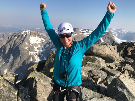
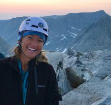
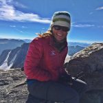
As I write this, I feel exhilarated and inspired. You see, I got to stand at the top of Wyoming’s tallest mountain, Gannett Peak, last Thursday.

I hike about 1,000 miles a year, and I’ve climbed several peaks, including Wind River Peak, Fremont Peak, East Temple, Mitchell Peak, Lizard Head, the Grand Teton, Mt. Whitney, and others. But until last week, I had never even laid eyes on my state’s tallest mountain. So excuse me for my exuberance, but now that I’m back in the lower regions, I’m remembering what I saw higher up…

And, just so you know, this is a very long blog post. As Mark Twain said, I would have written less, but I didn’t have time. I am behind at work from being in the wilds for 6 days, and yet I wanted to capture this experience, and to share it with others, while it’s so fresh in my mind. So, thank you in advance if you read what is a long-form article.

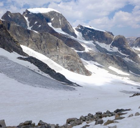
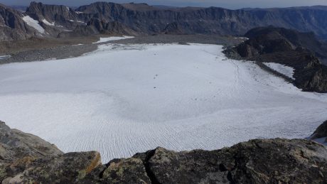
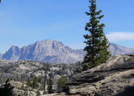
The very isolated Gannett Peak stands 13,809’ tall. It is the high point in all of Wyoming, and that fact is what draws many to the area to climb the mountain. For the record, Gannett’s status as being the high point in Wyoming is actually not the main reason I wanted to climb it. I was most interested in seeing what is very much, despite its height, a “hidden” mountain. I also wanted to see and travel over some of the last remaining glaciers in the Lower 48, including Gannett Glacier, on the north side of the peak, which is apparently the largest glacier in the Rocky Mountains south of the Canadian border. I’m always looking for interesting experiences, and climbing Gannett fit the bill, and then some.

I am in mountain climbing shape, and have years of backpacking experience, but I don’t have technical mountaineering expertise. So to climb Gannett, I signed on with Jackson Hole Mountain Guides for a guided expedition. 

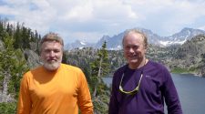
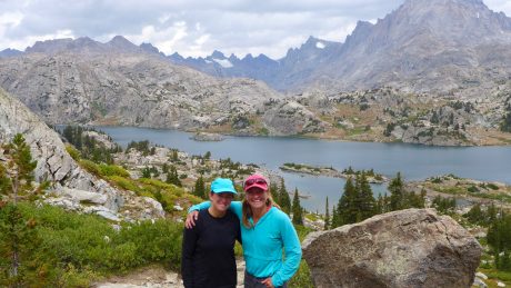
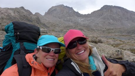
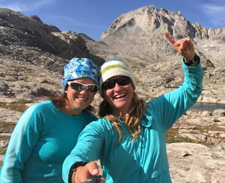
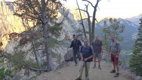
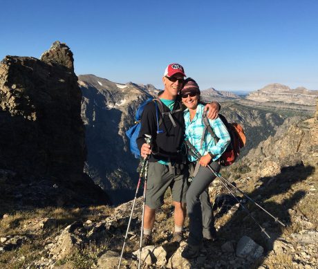
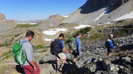
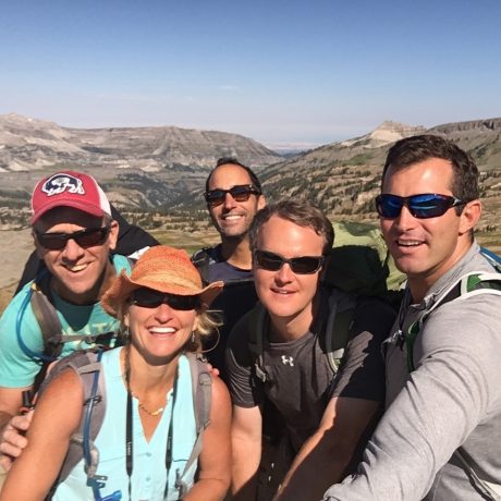
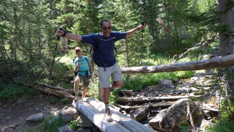
There were two others signed up for the same expedition – Rick, from Texas, and Robert, from Mississippi. Rick and Robert are “High Pointers.” If they could summit Gannett Peak, it would be #47 out of 48 for them. (BTW, since my return, I think I am talking with a bit of a Southern accent, the result of being around Rick’s and Robert’s charming southern voices for 6 days.)

Robert and Rick, best friends and “high pointers.”

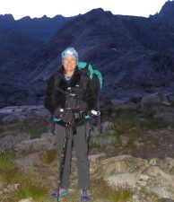
Nate Opp would be our guide. Nate was one of the guides who led me up the Grand Teton in 2009, and I like his style, so I was psyched he would be the one facilitating the meaningful adventure for us.

From what I can tell, there are three ways to approach Gannett Peak, from the West, via Elkhart Park, or from the East, via Glacier Trail, near Dubois, WY, or via Ink Wells and the Wind River Indian Reservation (with permits, etc.) 

The expedition would be six days, which at first to me, seemed like a long time required to climb a peak. (I don’t recommend it, but I’ve climbed Wind River Peak, and other lesser peaks, in a single day. Most often, though, I will take 3-4 days to hike a long ways and climb a single mountain peak in the Wind Rivers.)

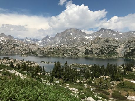
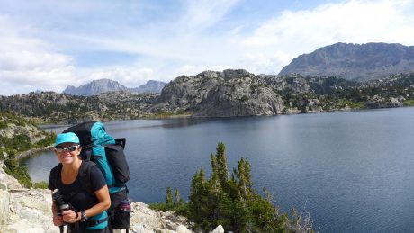
But when I looked at the maps, six days made perfect sense. Anything less than that, from the West side, seemed almost unreasonable, given variables like the weather, and snow depths and conditions, the altitude, etc. I could have signed on with another reputable company and approached from the East side, which was closer to my home of Lander, and the expedition would have required only 5 days’ time. But when I saw the route from the West approach, and realized it went through Titcomb Basin, I was even more excited. I had been into Island Lake and into Indian Basin (and up Fremont Peak) before and it is one of the most stunning regions I have ever seen.

“Summer breezes caressed me, my legs stepped forward as though possessed of their own appetites, and the mountains kept promising. I stopped before the trees were gone, not ready that day to disappear entirely into the vastness. Perhaps these spaces are the best corollary I have found to truth, to clarity, to independence.” – Rebecca Solnit, A Field Guide to Getting Lost

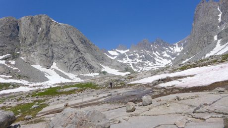
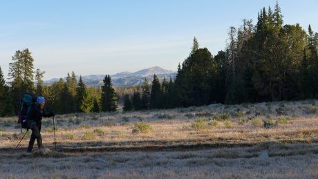
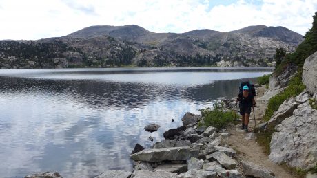
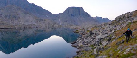
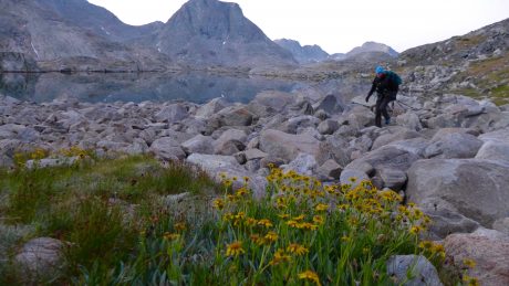
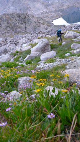
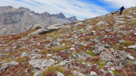
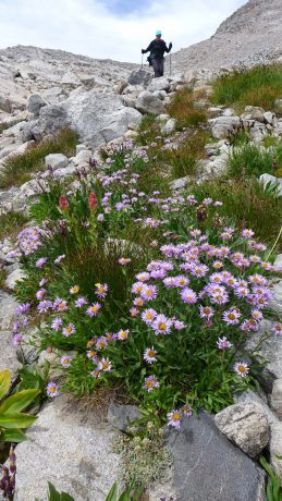
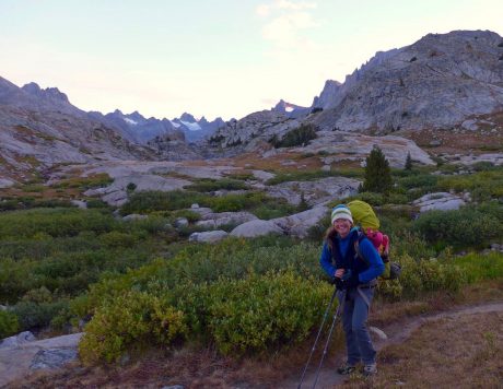
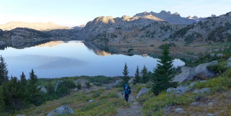
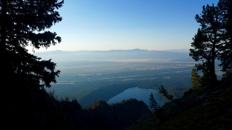
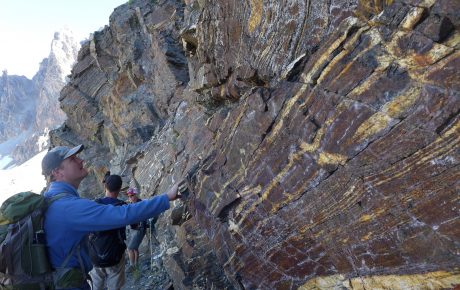
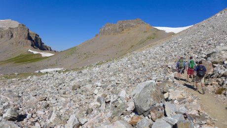
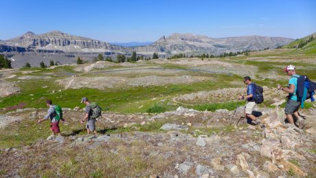
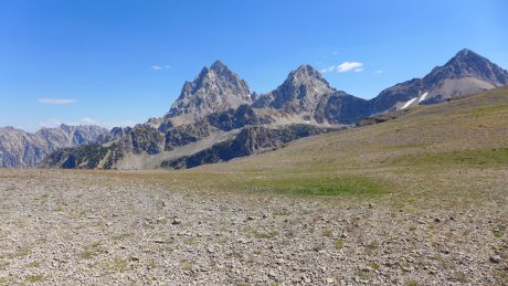
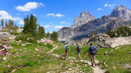
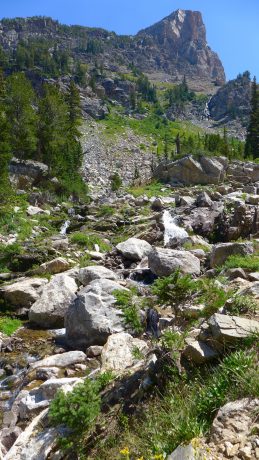
Day 1: I love that quote from one of my favorite writers and books. We started at Elkhart Park trailhead, near Pinedale, WY. From there, we hiked 13 miles, passing many beautiful lakes, including Barbara, Hobbs, Seneca, Upper Seneca, Island and others. As soon as I started hiking, my legs stepped forward as though possessed of their own appetites, and the mountains kept promising… 

Nate, Robert and Rick, hiking alongside Seneca Lake on Day 1.

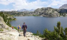
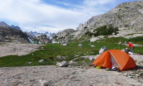
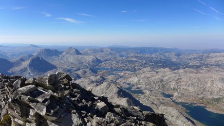
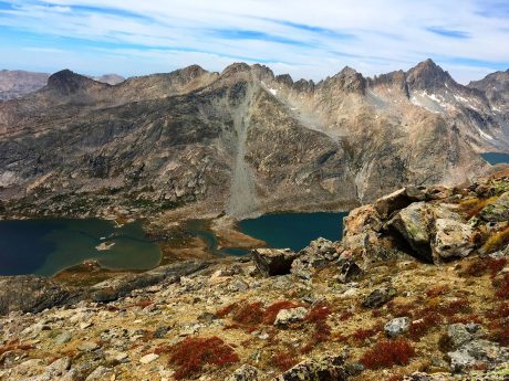
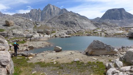
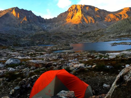
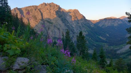
We pitched our tents in Titcomb Basin, just past the Indian Basin Junction. We had a huge waterfall feature right near our tents, that included several cascades that drained into a lake that was below, in view from our tents. We had stellar views, including one filled with jagged granite peaks and glaciers that beckoned. If all went well, we’d soon find ourselves deep in those mountains and glaciers…


Island Lake, reached at about 11 miles.

We hiked efficiently and arrived, and had our tents pitched by 3pm. I lounged around like a marmot on a big slab of granite under the warmth of the sun, while drinking in the waterfall soundtrack and the breathtaking views.

Not too shabby of a campsite. We’d camp here on nights 1 and 5.

The lounging lasted only an hour or so before the weather changed drastically, and we raced for our tents. While in my tent, thunder echoed raucously against the granite towers that surrounded us, followed by lightning that lit up my tent. I am terrified by lightning, and this reminded me of a night at Clear Lake with my family that was the most scary night of our lives.

That night, lightning lit up our tent repeatedly and thunder roared as rain poured down for several hours. I never prayed so hard, and it felt miraculous that we had survived the night. I had hoped to never find myself so high up in a tent under those circumstances again, which I know is an unrealistic hope. If I am going to play in the high country, there will almost certainly be some thunder and lightning. (And it didn’t help that I recently read the fantastic book, A Bolt from the Blue, about the terrifying (and heroic) rescue in 2003 at 13,000′ on the Grand Teton. The page-turner-of-a-book tells the true story about a colossal lightning bolt that struck and pounded through the body of every climber in a group of six. 

I know, I know – these things are not helpful when laying alone in a tent at 10,500′ that is getting lit up by lightning just seconds after raucous thunder echoes against the nearby granite mountains… I work with leaders and coach people all the time about the opportunity we have to “choose our mindset.” The late Viktor Frankl, an Austrian psychiatrist and a Nazi concentration camp survivor who wrote the influential Man’s Search for Meaning, argued that the last of the human freedoms that cannot be taken from us is our choosing how we will respond to our circumstances. I remembered this, and the work I do, and tried to change my “I’m going to be struck by lightning and die out here” mindset to “What a spectacular storm!” mindset. It didn’t work, but it wasn’t for a lack of effort.

So I lay there, uneasy and a little bummed that this adventure was off to this kind of start. I got out my journal and found notes from each of my three sons and my husband in the back. I read those a few times, and felt comforted. I know how blessed I am to have a family who supports these epic adventures of mine, and their thoughtfulness touched me. Luckily, the storm was short-lived. After about an hour and a half, the storm passed through, and we had blue sky and sunshine again.  

After emerging from the storm, and our tents, Nate made us an epically delicious dinner of tacos, complete with guacamole, and peppers and salsa. We all ate like people who were super duper hungry. 🙂

I was getting to know Rick and Robert by now. After hiking several miles together, and now having shared our first meal together, we were acquaintances. I liked them immediately. They are kind, Southern gentlemen. 

For the first time since starting Epic Life Inc., I chose to forego leading my flagship program, Epic Women, this summer. Every year at this time, I am leading my Epic Women expedition in the Wind Rivers. I coach women individually for several months, and then they all come together to meet for the first time, and we go into the wilderness to backpack and climb mountains.

This year, I wanted to do something personal instead. I was longing to do something new, and that would challenge me and expand my abilities. I also wanted to see some new sights, get inspired, to enjoy some solitude, and to not be in charge.

Like me, Rick and Robert were excited to be in the wilderness, and on an expedition to climb Gannett. Robert and Rick have been best friends for 40+ years. (It’s funny; I’m working right now on a project I’m calling Project Friendship. I’m reading a lot, and writing a lot, about friendship. I’m doing a lot of personal research on friendship, which is a source of great inspiration for me right now. And here on my Gannett Expedition, are two people who have been best friends for 4 decades. I always say, there are no coincidences…)

Robert and Rick are both avid drummers and musicians, and that’s how they originally met. For the last 10-12 years, they’ve been traveling the country bagging the high point in each of the states in the Lower 48. If they could stand on Gannett, it would mark their 47th of 48 high points.

After day 1, I felt reassured that the Universe arranged for Rick and Robert to be my trail comrades for such an epic adventure. And, we had a guide that I trusted. So far, so good…

“Being in the wild gathers me. It astonishes me. It quiets the negative voices inside of me and allows the more constructive ones to talk. It humbles me. It reminds me of how small I am, which has the reverse effect of making me feel gigantic inside.” –Cheryl Strayed


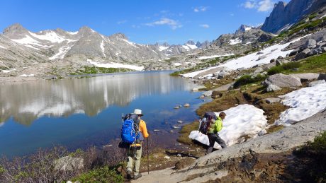
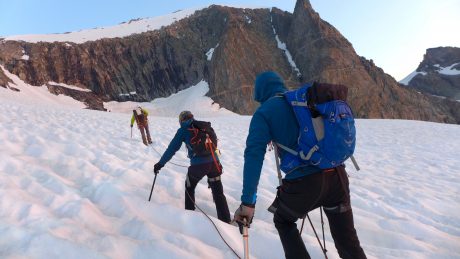
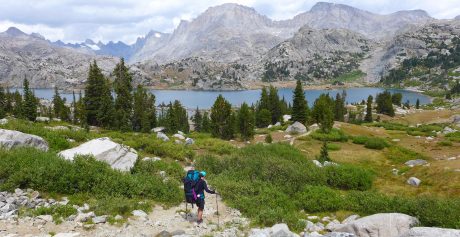
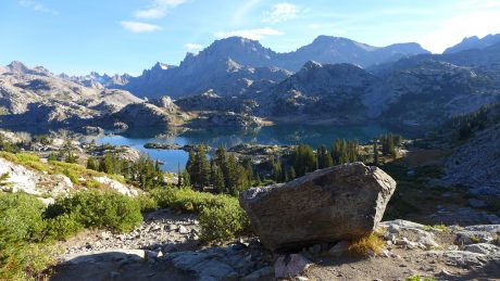
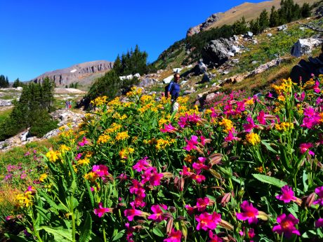
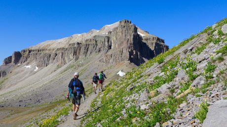
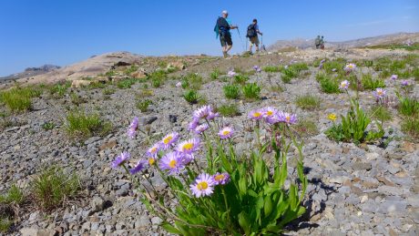
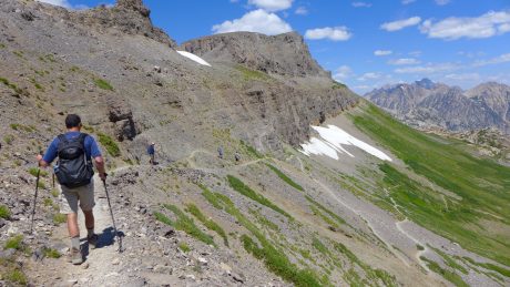
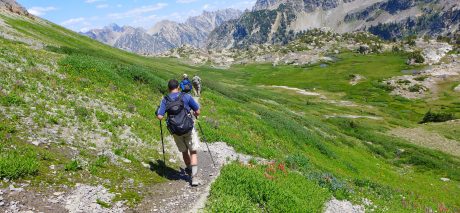
Day 2: We woke up at 7am, and had coffee while Nate cooked us a great breakfast of Huevos Rancheros. Mid-morning, we broke camp, and backpacked to the uppermost reaches of Titcomb Basin.

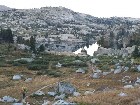
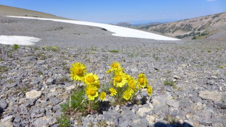
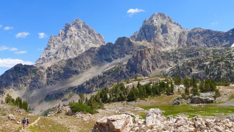
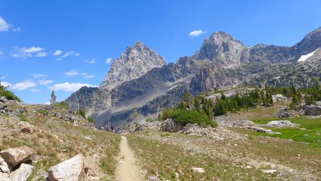
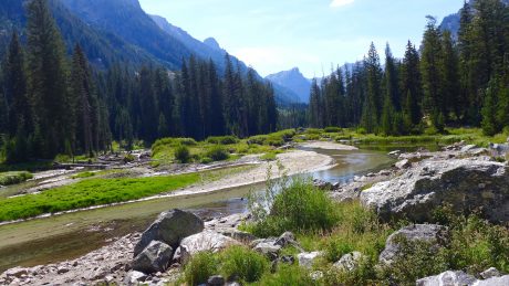
We hiked through wildflowers, snow, and alongside several lakes that were smooth as glass and that reflected the snow-capped, looming granite peaks in their waters. I was captivated the entire way. I’ve got many favorite trails and areas in my beloved Wind Rivers, and Titcomb Basin is at, or near, the very top of that list. It is incredible.  

Nate and Robert, hiking past one of the many upper Titcomb Basin lakes.
Nate Opp, our very capable guide from Jackson Hole Mountain Guides.

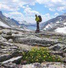
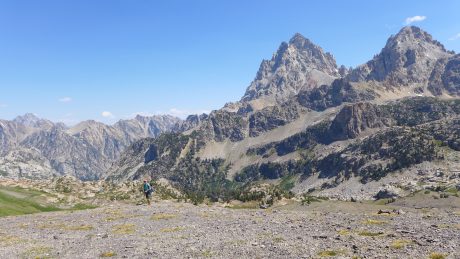
It’s impossible to not feel tiny in this country. And, as writer Cheryl Strayed so eloquently wrote, this has the reverse effect of making me feel gigantic inside. Huge, granite mountains towered above us as we hiked, and only a wide angle lens has any chance of capturing the alpine tundra, lakes and mountains in a single shot.

I spied these goats near our camp in the upper reaches of Titcomb Basin.

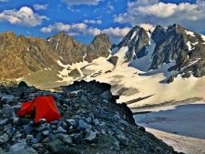
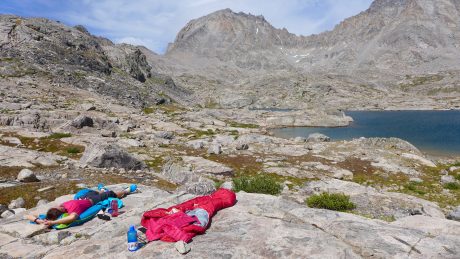
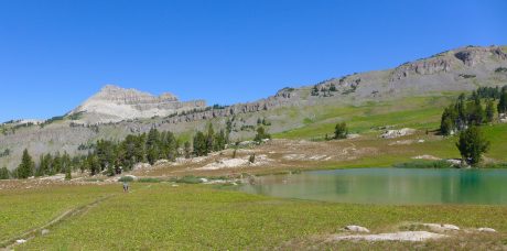
After about 6 miles, we pitched our tents as close to the base of Bonney Pass as possible. Ours was truly one of the most scenic campsites I have ever enjoyed. We were right under the towering Mt. Helen, and other tall peaks.

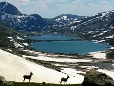
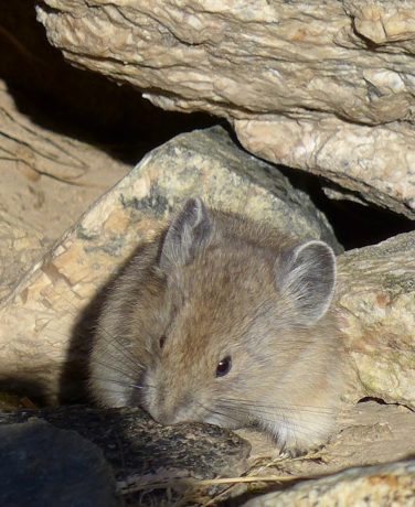
As I was pitching my tent, I spied movement out of the side of my eye. It was a herd of about 20 goats –- bighorn sheep ewes? I wandered quietly toward them and was able to watch them for some minutes. (see photo or video) We were all excited to see the wildlife, as we had only seen some songbirds, squirrels, marmots and pika, and weren’t expecting to see much in the way of wildlife on this trip.

Here’s a short video clip of the goats:

Our tents were right underneath Mt. Helen, lit up by evening alpenglow here.

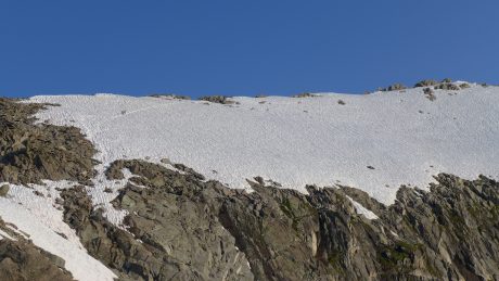
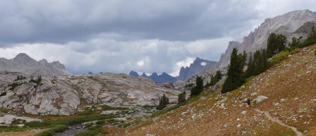
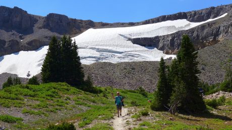
Our camp was surrounded by massive snow fields that adorned the towering peaks that jutted up from the alpine tundra all around us. We had a huge winter in Wyoming this year, and there was still abundant, melting snow all around us. And, close in our sight, was what would be one of the cruxes of our Gannett Peak summit ascent– Bonney (Dinwoody) Pass.

The pass is about 1,200 feet tall, and it’s steep (like in 45 degrees? steep), and mostly covered in snow. I have fitness for hiking up steep hills, but this would be different. We’d have crampons and helmets on. We’d be roped up. We’d have our ice axe at the ready for self arrest, and it would be, well, a serious undertaking, with high consequence should something go wrong.

The other thing about approaching and summiting Gannett from the West side is you have to not only go up Bonney pass, but down it, and across Dinwoody Glacier before you go up to Gannett’s summit. And, well, what goes up and down and up, goes down and up and down on the way back. It would be a truckload of hard-earned effort, and all of it technical and with high consequence.

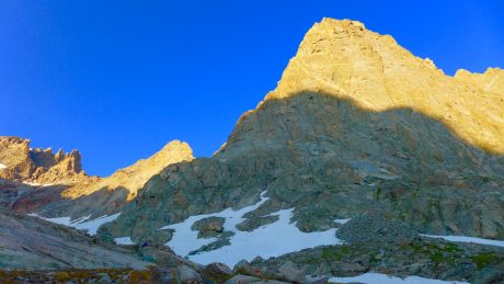
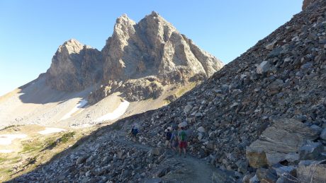
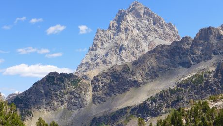
I’ve hiked literally thousands of miles in these Wind River mountains during the last 20 years, but never had I spied with my own eyes the state’s tallest peak.

Gannett is remote, and very much hidden. So while I was a bit afraid of the task of ascending the steep pass, I could hardly contain my excitement for the sight that awaited me once we crested it. 

Not only would I see Gannett Peak, but the map I studied indicated the view I’d get from the top of the pass would be full of glaciers. Last year, I climbed Fremont Peak with a friend, and was blown away when we got to the top of Fremont, and was rewarded by sights of the huge Fremont Glacier, and other glaciers in the distance. That sight had whetted my appetite. I wanted to see more glaciers in my backyard.

We enjoyed another great dinner that night, and we all talked nervously, but excitedly, about the next day’s plan.

I didn’t sleep a wink on night 2 because I just couldn’t wait to see Gannett Peak for the first time. I was just too excited for slumber.

“We cannot lower the mountain, therefore we must elevate ourselves.” – Todd Skinner

Day 3: Whenever I’m traveling, or camping in the wilderness, upon first waking, I always am a little disoriented and have to quickly search my brain for where I’m at. As my eyes first opened on Day 3, and I remembered where I was and what I was doing in Titcomb Basin, the above wise words are what came to mind. The late Todd Skinner was a friend, and a climbing legend, and an inspiration to so many. Today would be the first day of this expedition to really test my mettle.

Looking back at Rick and Robert, as we headed toward our first real crux of the expedition, Bonney Pass. That pattern in the snow is called “snow cups.”
That’s Bonney Pass, ahead, and at top left of the photo. This is on Day 3, our start toward Gannett Peak…

I have leveled up my whole life. By leveling up, I mean I have signed up for or tried things I didn’t have the skills to do. Even though I may look like a fool, stumble, or fail, I believe in doing hard stuff. Abraham Maslow called it self actualizing, when we become actually what we are potentially. We can’t ever realize our potential without leveling up and daring to fail and doing hard stuff we don’t know exactly how to do. In short, I get a lot of fulfillment out of learning, and whenever I level up, I am guaranteed to learn new skills, not to mention more about myself.

Although we wouldn’t climb the mountain until Day 4, we’d start our “climb” today, on Bonney Pass. I was uncomfortable just thinking about what would be required. But as Todd said, we cannot lower the mountain, we have to rise up to meet it.

We were all up early, and Nate had coffee on for us before feeding us a breakfast that included bacon. Yes – you read correctly, bacon! Those who know me know that bacon is one of my favorite foods, so this made me extremely happy. The day was already a winner.

Nate was one of the guides who helped lead me to the Grand Teton’s summit in 2009. I like his style, and he’s very experienced, so although our adventure was full of uncertainties, one certainty was that we were in very capable hands.

During the previous day, and again over breakfast on Day 3, Nate shared and reviewed his vision for our expedition, which was to “slim our loads way down,” making them as light as possible while still carrying tent and sleeping bag, cook stove and food and clothing layers. We’d take our slimmed-down backpacks up and over Bonney Pass, down and across Dinwoody Glacier, before ascending a small outcropped ridge that’s situated about 2,000’ below Gannett Peak. There, we’d put in a camp for the short night before our summit attempt.

Nate explained this would make for a more reasonable summit day on Day 4, not to mention a richer overall experience. (Many who approach from the West side, via Elkhart Park, go up and over Bonney pass, across Dinwoody Glacier, then up to Gannett’s summit, and then all the way back. It can make for a 14-hour day for the most fit, and a 20-hour day for “average” adventurers, especially for those coming from sea level.) Even if we had the fitness for it, it didn’t sound very appealing, and Nate’s vision and reasoning were compelling.  

When on a mountain climbing expedition, I want to climb a mountain, but I also want to maximize the experience. I’m willing to wake up at an hour in the wee hours of the morning to get a good start before the sun comes up, but if possible, I’d like for most of the experience to be during the light of day so I can see all of the awe-inspiring sights. I don’t want to experience half of the journey in the dark, and I want to be able to linger at least a little in such an awesome, and hard-to-get-to, setting. Add to that, ascending and descending the treacherous and steep Bonney Pass at the end of a Gannett Peak summit day is hard enough without having to do it twice in a single day. (That’s why when I climbed the Grand Teton in 2009, I opted for the 4-day experience with Jackson Hole Mountain Guides instead of the two-day option. I definitely had the fitness for the accelerated trip, but I wanted an optional summit day in case weather wasn’t favorable, and also, very importantly, I wanted to spend a night in celebration at the incredibly scenic high camp rather than rushing down a steep mountain to re-enter my civilized life more quickly than necessary.)

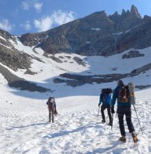
After breakfast and reviewing our plan, we cached the food and supplies we chose to leave behind, put our crampons and helmets on, and headed toward Bonney Pass.

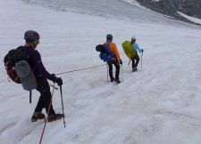
At first it was easy going. We walked on a gradual uphill to the base of Bonney Pass, and I got used to walking on snow while wearing crampons. Once at the base of the pass, Nate roped us up and gave us some instructions.

Mountaineers rope up to mitigate the risk of of falling on steep, hard snow or ending up in a crevasse. Should a person fall on a steep snow slope, someone, or all, in the roped group will help to use their ice axes to stop the person from falling and/or pulling everyone down the slope with them. Or, if a person were to fall into a crevasse while traversing a glacier, being roped up and spread out will hopefully prevent that person from falling to his/her death or from suffering serious injury.

Roped up and making our way up the steep Bonney Pass.

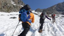
Nate explained we should keep the rope between each of us taut, not slack. Rick and Robert had much more experience with this kind of travel than I did. (They recently summited Mt. Rainier and Mt. Hood.) For me, this roped travel took some practice, but we were soon moving in a pretty good rhythm up Bonney Pass.

This day’s effort would be a quiet one. There’s not a lot of chit-chatting when you’re mountaineering over terrain that is treacherous, and where the risks are high. Intense focus is required. Your mind doesn’t wander. It can’t, and it doesn’t want to. Thankfully.

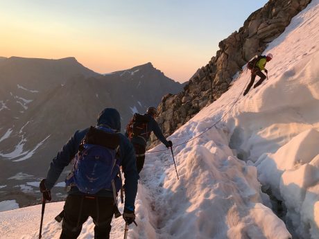
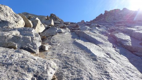
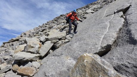
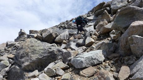
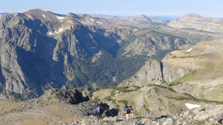
When we got about two-thirds of the way up the pass, Nate suggested we move to the rocks on the left to finish our ascent of Bonney Pass. Even though the rock was loose and the slope steep, with its own set of dangers, Nate explained the risk was less significant than a fall on the steep snow slope from upper Bonney Pass. So we de-cramponed, and while remaining roped together, scrambled our way up through boulders and over loose rock until we reached the top of Bonney Pass. At the top, we unroped, and Nate instructed us that once we crested the pass, we should take a load off for a few minutes to drink some water and eat a snack.

Gannett Peak reveals itself. (Look closely at the tiny ant-like specs in the center of this photo. Those are other climbers making their way toward us, traversing Dinwoody Glacier.)

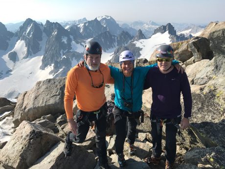
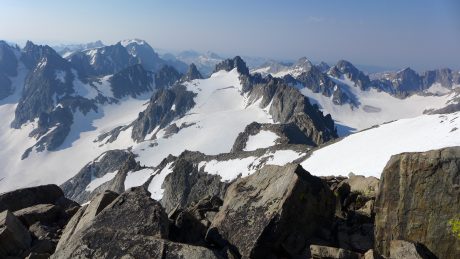
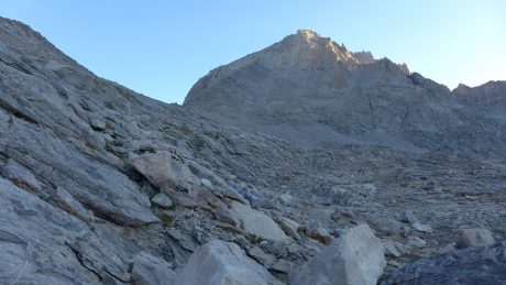
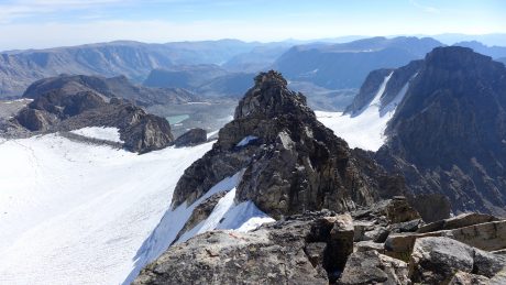
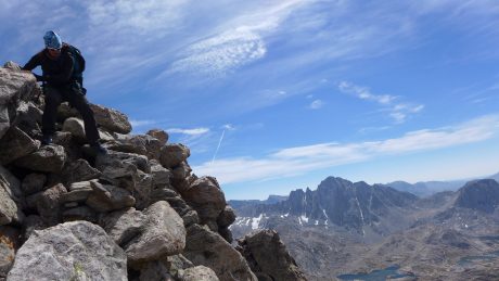
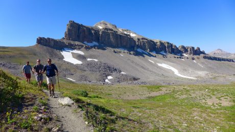
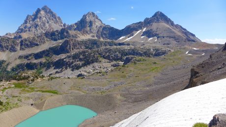
As we crested the pass, the hidden giant that is Gannett Peak revealed itself. It was tall like I expected, but it appeared more massive than I expected. I listened to hear the reaction of Rick and Robert and didn’t hear anything. (One of my very favorite parts about hiking with others in the Wind Rivers, is witnessing their reactions to the beauty that unfolds before them at different points of an expedition.) There was not a peep out of Robert and Rick. I smiled to myself because I assumed they were thinking what I was thinking. Excuse my language, but it went something like this: “Holy Shit.”

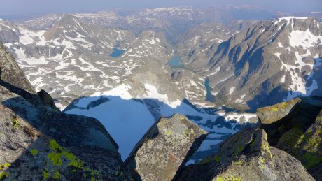
I was so excited at seeing Gannett for the first time, and in awe over all of the glaciers that lay before us. There was nothing but snow, glaciers, and towering granite peaks. The sight took my breath away, and mentally, was hard to process. (When I saw the Grand Canyon for the first time, my experience was similar in that I couldn’t find words to describe what I was experiencing, and it took a minute, or more, to fully process that what I was seeing was really real.)

Gannett Peak gets it name from Henry Gannett, who was an American geographer who is described as the “Father of the Quadrangle,” which is the basis for topographical maps in the United States. With 290 miles of isolation from a higher peak, Gannett is the most isolated peak in Wyoming, and the ninth-most isolated peak in the contiguous United States. With 7,076′ of clean prominence, the mountain is the most prominent peak in Wyoming.

It was certainly prominent as I looked at it, in awe.

We didn’t linger because we had a tall order ahead still, and an even taller order the next day. We finished our break, and put on our crampons again. Nate told me I’d go first on the descent. I don’t have much experience with crampons, let alone leading a group of people down a very steep and snow-covered mountain pass. I used crampons briefly, while ascending and descending a gully on my Mt. Whitney mountaineering expedition a few years ago, and briefly on my 2009 Grand Teton expedition, but nothing to this extent.

Did I mention how steep it was? When I asked how to proceed, Nate suggested I just go straight down the pass, with no switchbacking. To start, just try digging your heels in, he said. I used an ice axe in one hand and a trekking pole in the other to help balance myself, and away we went, slowly but surely, down Bonney’s very steep back side.

Me, on the lead, after descending Bonney Pass and heading across Dinwoody Glacier toward Gannett.

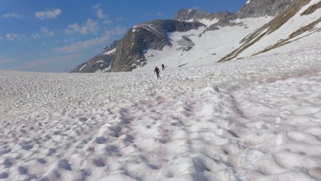
Up ahead, I could see several individuals coming toward us, spread out, appearing as tiny as ants, traversing Dinwoody Glacier.

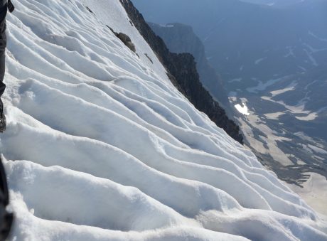
The snowy slope we descended was full of “snow cups.” The sculpted cupped pattern of the snow resembled ocean ripples, only these were white snow ripples. Often, the snowy slopes we traversed, or ascended and descended, resembled corduroy with extra tall “ribs” that stretched the entire vertical length of the slope. It was beautiful.

By the way, four different times during a two-day period, I saw people I know. The Wind Rivers are vast, and remote, and no matter how many people I might know, I’m always surprised when I see someone I know in the remote reaches of the Wind Rivers. As we made our way down and across the lower portion of Dinwoody Glacier, we passed a guide who was roped up to a client. “Hi Shelli,” the client said. I didn’t recognize him at first because he had a helmet and glasses on, so I said, “Who’s that?” It was Kirk VanSlyke, a former Lander man who was a few classes ahead of me in  high school. He now lives with his family in Dillon, MT.

As we continued, silence returned. The day’s work was quiet work. All I could hear was what would become a very familiar soundscape over the next several hours – our measured breathing, and the repeated sounds of our ice axes and crampons digging into the snow.

I noticed the longer I spent attached, literally, to Robert, Rick and Nate, the more connected I felt to them. Each of our safety depended on one another, and even though there weren’t a lot of words spoken when traveling over and through such high consequence terrain, a bond was developing over the course of our expedition. I could feel it, and found comfort in the fact that these guys had my back, and me, theirs.

I also found the single-minded, single-tasking a welcome reprieve from my busy mind. My mind is always thinking and tends to be future-oriented. Traveling on snow and up and down steep terrain, roped to one another, forced me to focus on only the next step, and then the next step, and then next step, for hours at a stretch. It was hard, but also unusual for me – and fantastic. The simplicity of it all was refreshing.

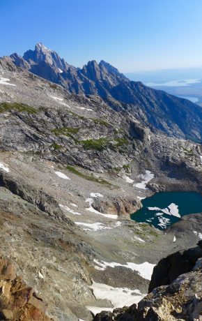
By 2:30pm, we reached the spot at almost 12,000’, situated directly under Gannett Peak, where we would pitch our tents for the short night. This was one of the most scenic campsites I’ve ever had. My tent was pitched under Gannett Peak, which I could clearly see, and on one side was Dinwoody Glacier, and on the other was Gannett Glacier. The rest of the scene was filled in by other glaciers, snow fields and tall, towering granite peaks.

Once we were out of our crampons and on level ground and safe and sound for the time being, I reflected on the day’s adventure. I felt exhilarated. It was a day of leveling up, of seeing new and astonishing sights, and I was filled with anticipation, and nerves, about the summit attempt that was only hours away.

Best high camp ever!

Here’s a short video clip of tentsite at 12,000′, situated under Gannett’s summit and surrounded by glaciers and other tall mountains:

We ate an early dinner that hit the spot – cheesy potato soup with sausage and bacon bits. (Nate’s a great cook!) We reflected on the day’s effort, and agreed on a wakeup time of 3:30am for our summit day. The afternoon and evening were stellar. Blue sky, a fantastic warm and bright orange sunset, and a bright moon bid us good night as we headed into our tents early.

(I am probably being generous, but I think I slept about 20 minutes total. I never sleep well the night before a summit attempt, and well, this summit would be an extra big one for me.)

“You will either step forward into growth or you will step back into safety.” –Abraham Maslow

Day 4: At 3:30am, I woke up from not sleeping, and stumbled out of my tent with my headlamp on to find Nate boiling water for coffee and a quick oatmeal breakfast for us. 

I have always wanted to climb things so I can see what the view is from “up there.” Today, specifically, I hoped to stand at the very top of Wyoming.

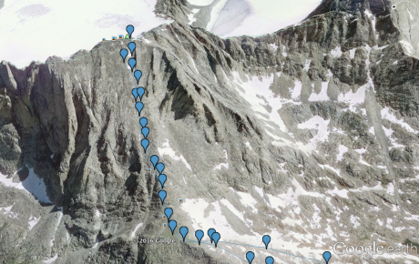
Our plan was challenging, yet simple: We’d summit Gannett, then return to our tents, break camp as quickly as possible, and continue down and across Dinwoody Glacier, and up and over Bonney Pass.

If it was just a matter of fitness, it wouldn’t be that big of a day. It would be hard, but not exceptional. But we had all kinds of variables to consider, not to mention risks. We’d be walking across and up snow, across and up glaciers, including the very steep Gooseneck Glacier, scrambling up steep sections of boulders and loose rock, and along Gannett’s exposed ridge which marks the final stretch to the mountain’s summit. And that would be just for the summiting portion. Then we’d reverse all of that, plus add some glacier travel, and a steep and high consequence ascent and descent of Bonney Pass at the very end of our day.

I won’t lie, part of why I signed up for a Gannett Peak climb was to push my limits. I wanted to step forward into growth a lot on this trip, and I knew today would deliver that, and then some.

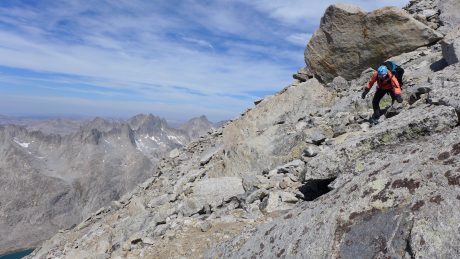
At 5am, with headlamps, crampons and light packs on, we started up the snow to start our ascent of Gannett. After about 10 minutes of snow travel, we removed our crampons, restocked our water bottles from a spring, and then, roped up, and followed Nate up a steep section of boulders and loose rock.

My trail name is “Sunrise.” I got this name because the first light of day is my favorite time of day, and I often insist on starting in the dark so I can be in the wilderness or on the mountain when the sun comes up. So I was a happy camper when we were soon rewarded with a glorious sunrise! (Watching the sunrise made me recall the words of one of my favorite poems, Why I Wake Early, by Mary Oliver, which I know by heart: Hello, sun in my face | Hello, you who made the morning and spread it over the fields and into the faces of the tulips and the nodding morning glories, and into the windows of, even, the miserable and the crotchety – best preacher that ever was, dear star, that just happens to be where you are in the universe to keep us from ever-darkness, to ease us with warm touching, to hold us in the great hands of light – good morning, good morning, good morning. Watch, now, how I start the day in happiness, in kindness.

Me, very happy because it’s sunrise AND I’m climbing a mountain, two things I love dearly.

Next, we crossed a section of snow toward what’s known as the Gooseneck Glacier bergschrund, a crevasse that opens as the summer gets going and the snow melts. Lucky for us, while the bergschrund was starting to open, it had a “snowbridge”near/over it making it passable. The crux of the route begins here. The Gooseneck Glacier / couloir is steep and narrow, and makes your stomach turn when you look down and imagine the what ifs. I took a deep breath, and took some of the most deliberate steps of my life.

Making our way around the thankfully-not-yet-completely-opened bergschrund on Gooseneck Glacier.
Headed toward the summit, which you can see at top center of the photo.
This is a photo of the final ridge line approach to Gannett’s summit. Look very closely at the upper left to see two mountaineers en route to the summit.

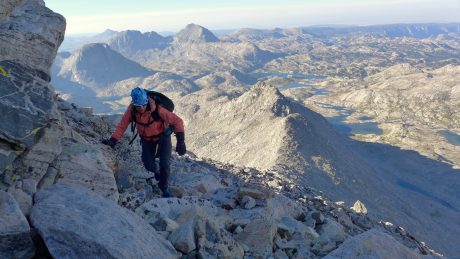
After getting up and through that section, we returned to class 3 rock scrambling, all the way up to the snow-covered face of Gannett, where we put our crampons back on to walk the ridge line to the summit. The final stretch was one of my favorite parts, and certainly one of the most exhilarating. The ridge is narrow, and on the left you can enjoy summit views of lakes and mountains everywhere below. As we made our way to the summit, we’d get glimpses through the rocky ridge on our left to all that was below and beyond. To our right was a steep, completely exposed, snow-covered face.

Steep and exposed, and beautiful snow patterns from the final ridge that leads to Gannett Peak’s top.

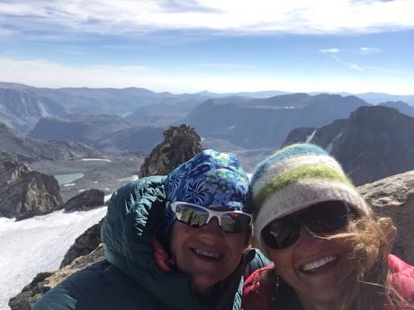
Compared to the rest of the effort, the final stretch to the summit is pretty level, even if it’s extremely exposed. I always feel at my fullest potential right before summiting – when the summit is in reach and right before I stand on it. I felt as though I was on top of the world, even if it was actually just on top my beloved state of Wyoming.

We enjoyed a half hour or so taking in the panoramic views and reflecting out loud about what we had just experienced. I sent a couple of texts with a summit photo to my husband and sons, my parents, etc., and then we reminded ourselves that that summit is only the ⅓ way point. (The saying usually is “The summit is only the halfway point.” And, in fact, most injuries occur on the descent of a mountain.)

Yeehaw! Posing with Robert and Rick on the summit of Wyoming’s highest point.
One of our summit views.
Another summit view.

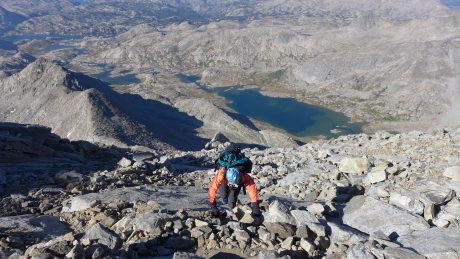
In our case, we had to descend the mountain, break down our camp, and go down, and then up steep Bonney Pass and then descend the steep and treacherous Bonney Pass and eventually get back to our camp, hopefully in one piece, and hopefully before any significant changes in weather. It was a tall order. So we celebrated on top of Gannett, but not for too long, before descending, very carefully, 2,000’ to our tents.

We were methodical and efficient in our descent. After breaking down our camp in short order, we started our return journey.

Just as we imagined, ascending Bonney Pass was a grunt. We took a very short break at the top, and then braced ourselves for what Nate suggested might be the biggest crux of our day – getting safely down a treacherous Bonney Pass on tired legs and lungs. We remained roped up, but removed our crampons at the top of the pass, and followed Nate’s lead down a bunch of rock to mitigate the risk of a steep and dangerous fall on the top of Bonney Pass. About halfway down Bonney, we put our crampons back on and I took the lead and down we went, slowly, but steadily, so as to get this day’s adventure behind us as safely and as soon as possible.

We managed to get back to our main camp at the upper most reaches of Titcomb Basin by 5:30pm. We were all pretty wiped out, but it was great to be on firm and level ground, and finally, to fully celebrate what we had accomplished – standing on the top of Gannett Peak!

As per usual, Nate spoiled us with another hearty dinner. This time it was stuffing, mashed potatoes and gravy. We all ate as if we were very hungry mountaineers. It was a great feast, and we all recalled and replayed the events of the day. We were all filled with joy, but also a sense of relief. We had had success, and suffered no injuries or tragedies.

I shared with the group that my FitBit logged 20,547 steps for the day. And they weren’t just any steps. Every single one of those 20,547 steps were “high consequence” steps. Not many words were spoken during the 12-hour adventure, except for the short time on the summit, and when instruction was offered to us from Nate. Otherwise, Rick, Robert and I were completely focused on every single step. Until then, I had never engaged in such a sustained, high consequence experience. Being on the brink of safety, where the stakes were so high almost constantly, had the effect of making me feel so alive. (By the way, I can’t say enough how impressed I am with Nate, and other guides who must focus on their own individual steps and safety while carefully considering everyone else’s condition and every move.)

I have been fascinated by the concept of flow. Mihaly Csikszentmihalyi, a Hungarian psychologist, named the psychological concept of flow and describes it as “a highly focused state.”

Recently, I’ve read books about flow, including The Rise of Superman, and a more recent follow up book, Stealing Fire.

There are 17 triggers that can lead to flow state, and by all indications, this mountaineering experience we were having included several of them. One thing that is required to reach the flow state of mind is intensely focused attention. Check. Another flow trigger is having a clear goal. Check. We were very clear about our goal. There was no wondering about what our plan was each day on the expedition. Another trigger is the challenge-to-skill ratio. Check. For flow to occur, you need to be doing something that is harder than you’re capable of doing – that requires skills you may not yet have. This will prevent boredom while keeping you engaged and at attention for long periods of time. Another requirement for flow is high consequence. Check. Since we left our camp in the morning, every single step we took, and there were thousands according to my FitBit, were of high consequence. Rich environment is another flow requirement. Check. We were surrounded by a unique environment, rich in glaciers and tall and beautiful mountain peaks. Deep embodiment is another flow trigger. Once again, check. Deep embodiment means total physical awareness. This is when we harness the power of our whole body and pay attention to the task at hand. This also means paying attention to multiple sensory streams at once. No question, my senses were heightened every step on this day. I never felt so alive… even if I was mentally exhausted when we finally returned to our Upper Titcomb Basin camp.

But I digress…

While it was a physical endeavor for me, Gannett taxed me mentally more than it did physically.

So no surprise, once I could let my mind loose, I slept. Hard.

We all slept in, and it was a blissful experience. We had coffee and ate breakfast, and had one of many great mealtime conversations. As is often the case, the deeper we got into the expedition, the more we each let our guards down, and the more meaningful our conversations became. 

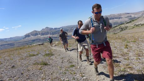
Around lunch-time, we broke camp and started our 6-mile hike back to our original camp. We all were still high from our accomplishment and the shared experience. Since today’s was a hike rather than a mountain climb, there were more words. At times we hiked together, but at others we spread out. I don’t know about Rick, Robert and Nate, but I spent my hike on Day 5 replaying the previous days’ events, and recalling the scenery I saw, and also taking notice of all of my spectacular surroundings.

I often go to the wilderness to be alone. I think Solitude is the medium for self realization, and I often yearn for time alone. I have a lot of natural enthusiasm and energy, but I also suffer depressive periods every now and again. I know from experience that getting away and going into the wilds is medicine for my soul. I think about this as I walk alone ahead of the group on Day 5. These days in the wilderness have done me good.

Robert and Rick make their way out of upper Titcomb Basin, as we head toward our last night’s camp.

I was reminded of a quote I highlighted in one of my favorite books, a Field Guide to Getting Lost, by Rebecca Solnit:

“As you step up to the ridgeline… The world doubles in size.”

I knew I would return from this trip as more than I was before.

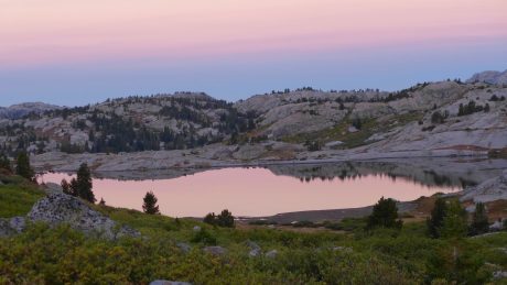
We had a glorious last night in the wilderness. We had a pasta dinner, and chocolate for dessert, and then enjoyed a sunset that painted the granite walls and peaks around us a deep pinkish-orange. The moon was bright, and almost full. Rick and Robert and I enjoyed the sunset together, and shared more stories and memories with one another, in between our reflections of what we had all experienced and accomplished together.

Here’s a short video clip of our last night in camp:

I went to my tent feeling extra blessed. I had not only climbed Wyoming’s tallest mountain, but I also made two new friends, and reconnected with a guide I deeply respect. I especially felt grateful for my family, who lovingly supports these adventures I want to experience, and felt, once again, restored and rejuvenated by my beloved Wind River mountains.

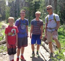
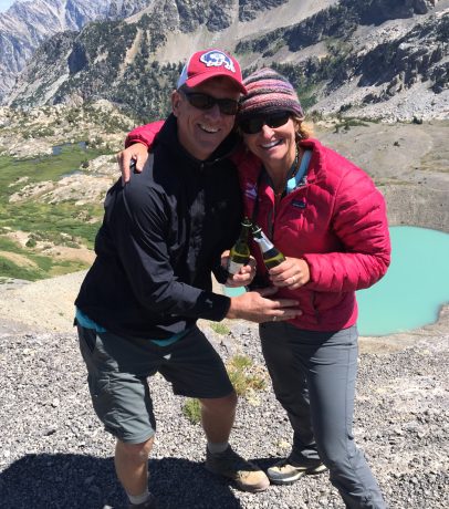
Day 6: Our last day’s hike out was about 13 miles. I couldn’t wait to see Jerry and the boys. They hiked in to meet me when I had about two miles left. They are the best support team a person could ever dream of having and I had a few happy tears when I spied them coming toward me.

(Side note: I was hiking particularly fast on this last day not only because I was eager to be reunited with my family, but also because I was chasing/trying to hunt down a friend of mine that I’ve never met in person. Her name is Kara, and she lives in New York. We have common interests and some mutual friends. Before our respective expeditions, we compared notes and discovered we’d both be somewhere in the Titcomb Basin region on Aug. 4 and early on the 5th. I looked for her on the trail on Aug. 4, but to no avail, and I tried to catch her on my hike out on Aug. 5. I had asked many incoming hikers if they had seen a group of four women, including one with braids and a headband, which is how Kara described herself when we agreed by email to look for each other “out there.” At one point, a hiker informed me that Kara and her group were only 1.5 miles ahead of me, but that was with only about 3 miles remaining to the trailhead, and unfortunately, I couldn’t close the gap!

My Epic family hiked in to meet me when I had about two miles to go on the last day. They are the best!

As if seeing my family wasn’t enough to make for a perfect ending to my Gannett Peak expedition, Jerry had a cooler of cold beers, an assortment of fresh fruit, and bags of salty chips ready for Nate, Robert, Rick and I at the “finish line.”

As I wrap this up, I’m also grateful for friendship, and the two new friends I made in Robert and Rick. I am looking forward to keeping in touch with them. I also am grateful for Nate, and for his skills and his leadership. Without him, I couldn’t have made this dream come true.

Filed Under: Fitness, Travel & Tourism Tagged With: epic adventure, gannett peak, high point, mountain climbing, titcomb basin, wind river range, wyoming

Wyoming’s Indian Basin and Fremont Peak – An Unforgettable Epic Adventure

August 30, 2016 by Shelli

You cannot stay on the summit forever; you have to come down again. So why bother in the first place? Just this: What is above knows what is below, but what is below does not know what is above. One climbs, one sees. One descends, one sees no longer, but one has seen. There is an art of conducting oneself in the lower regions by the memory of what one saw higher up. When one can no longer see, one can at least still know.–René Daumal

Howdy!
Howdy!

I am back in the “lower regions,” but still thinking about what I saw up high. As I write this, I’m still exhilarated from an adventure I experienced in my backyard, Wyoming’s Wind River Range, this past weekend. As you have gathered by the many blog posts I’ve published here, I spend a lot of time in Wyoming’s Wind River Range, which is essentially my “backyard.”

This blog post is my attempt to share about what I consider to be one of my most memorable Wind River epic adventures – time in Indian Basin and a climb up Fremont Peak. I apologize in advance for the blog post’s long length. But, as the saying goes, I would have made it shorter, but I didn’t have the time.

I put this adventure together at the last minute when a work trip was cancelled. I invited my dear friend, Kathy Swanson, to accompany me, and she said Yes.

I only had three days, and I wanted to climb Fremont Peak. I also wanted to experience the Indian Basin region, which I had read about in numerous stories and trip reports related to the Titcomb Basin region. My friend, and well-known adventurer and writer, Mark Jenkins, wrote about Indian Basin in a Backpacker article called “Perfect 10–North America’s 10 Most Memorable Hikes, “I’ve hiked trails from Tibet to Timbuktu and found nothing more gorgeous.”

And in 2012, my husband, Jerry, and I had taken a long day hike to Island Lake. I remember taking in the views of the lake, and being awe-struck by the big mountains beyond the lake, which include Fremont Peak. I promised to one day return so I could go deeper into the area. Last weekend was my chance.

The plan was to backpack in about 15 or so miles on Friday to Indian Basin, where we’d camp for 2 nights. On Day 2/Saturday, we’d climb Fremont Peak, and on Day 3/Sunday, we’d backpack back out.

Fremont Peak is the third tallest peak in Wyoming, and the second tallest in the Wind Rivers. At 13,745′ tall, it’s just 64′ lower than Gannett, the tallest, and 31′ lower than the Grand Teton (which I’ve also climbed). Fremont Peak is the tallest peak in Wyoming that doesn’t require technical skills or gear. The main reason I wanted to climb it is because directly on the other side of it (on its north side) is Upper Fremont Glacier, one of the largest and last remaining glaciers in the American Rockies. I couldn’t wait to look over the other side of the mountaintop to see that for the first time.

We started at the popular and well-used Elkhart Park trailhead near Pinedale, WY. We started up the Pole Creek Lakes trail with our too-heavy backpacks at 6am, and made great time. After about four-and-a-half miles, we took our loads off and snapped some photos at an overlook called Photographer’s Point. “There’s Fremont Peak,” I told Kathy. “That’s the mountain we’ll climb tomorrow.” She didn’t say anything, and I think she purposefully looked away from the view at that point. At a little over five miles, we continued on the Seneca Lake Trail.

Kathy, at about 5 miles into our 15.5-mile day.

A major highlight of this route are all of the lakes you pass. We hiked past Eklund Lake, an unnamed lake, and Hobbs Lake, before reaching the stunning, and rather large, Seneca Lake.

Kathy, at the beautiful Seneca Lake, reached after about nine miles.
Kathy, hiking around Seneca Lake.

The views of the mountains from Seneca Lake warrant a break, so we removed our packs and enjoyed a lunch break here before refilling our water bottles and continuing up. Shortly after Seneca lake, we hiked past Little Seneca Lake, and soon after, crossed over the Continental Divide Trail and continued up and toward Island Lake and Titcomb Basin.

At about 11 miles, we reached Island Lake. Seriously – this is such a spectacular scene I always feel like I have to check the map to make sure we’re not in Heaven. It’s that spectacular. We took our loads off here briefly to take some photos and enjoy another snack. I also commented about the clouds over the mountains, which were building up pretty quickly. I knew there was a chance for some weather today, but was hoping we’d reach our destination before it came to pass.

Kathy and I, posing at Island Lake.

I should probably mention here that Kathy doesn’t consider herself a backpacker, nor does she want to be one. She’s a phenomenal athlete, and is very adventurous, and we share a love for long distance day hiking. Kathy and I both “grew up” in Lander, WY, but she’s a year younger, and while we had some friends in common in those early days, we weren’t very well acquainted. It wasn’t until she read about my Grand Canyon rim-to-rim-to-rim, and other epic day hikes, that she reached out to me. That was about six years ago, and Kathy and I have since shared the trail on many epic adventures, mostly epically long day hikes.

But back to the point I was trying to make a minute ago… Kathy pretty much only backpacks when I invite her on one of these trips. In 2012, I roped her into going on a 3-day backpacking and mountain climbing adventure with me, along with two other  friends. The adventure served as a sort of “test drive” for a portion of my Epic Women expedition’s route. She was a great sport, even if she didn’t fall in love with carrying a backpack, “camping” without lawn chairs and a cooler of beer, and climbing mountains. (We climbed Mitchell Peak from Lizard Head Meadows, and she was terribly uncomfortable with every step, and although she did amazing, I wasn’t sure I’d ever find myself leading her up another mountain.)

The night before this adventure, when Kathy tried on her borrowed – and loaded – backpack, she remarked with a few choice words I don’t want to print here, along with “my knees just buckled.” She wasn’t joking. Did I mention Kathy is a trooper? She’s one of the very few friends I call when I have something this epic planned, and on short notice. So far she has always said Yes. But for the record, and to be completely up front, had she said No, I still would have set out on this adventure. That’s how bad I wanted to experience Indian Basin and Fremont Peak. That said, I was thrilled I had a taker in Kathy, because we always have meaningful conversations, a lot of fun and laughter, and we both love pushing our limits.

The reason I’m bringing this all up right here is that a little bit past Island Lake, about 11.5 miles into our backpacking adventure, I could sense that Kathy might be approaching that threshold at which things start to go downhill, and it’s not a lot of fun anymore. This has nothing to do with her fitness level and everything to with her borrowed, and heavy, backpack. Oh, and add to that she was experiencing significant pain in one of her ankles caused by her hiking boot.

All that said, Kathy is one of the toughest people I know, and she has a awesome attitude. About this time I was also worried about the clouds that were developing, and how torrential rains and prospective thunder and lightning might wear on her (us) should those conditions present themselves.

Kathy, leading us down the trail toward Island Lake.

After hiking down to, and around, Island Lake, we made our way up the trail to the Indian Pass junction. Here, we took a right and headed toward Indian Basin. Shortly after the junction, we came upon a young couple, and I asked them if they had been in Indian Basin. They said Yes, and then they asked where we were headed. I told them we were headed into Indian Basin, and that we had plans to climb Fremont Peak the next morning. They shared that they had climbed it earlier in the day.

Before our trip, I had talked to a couple of friends (Hank Williams and Gabe Joyes) about climbing Fremont Peak. Each of them told me that Fremont Peak was a “walk up,” and that I’d have no problem. I believed them, but was still interested in hearing a first-hand report from strangers. The couple, who was visiting from Grand Junction, CO, told us that the route up the SW buttress was pretty straight-forward, but that there were some pretty hairy sections that were loose, and some “Class 4” terrain. “But I’m sure you’re experienced, and will have no problem with it.” I felt assured by this, and yet the Class 4 comment wasn’t something I was expecting. Everything I had read about the SW route to Fremont Peak was that it was Class 3. I filed that interesting tidbit in my mind, but didn’t mention anything to Kathy, who was already terrified at the prospects of climbing a mountain. Before we parted ways with the couple, the man mentioned that there were some established sites protected by boulders in Indian Basin that we should look for, adding, “It’s a bit of a climb into Indian Basin.”

Kathy, heading toward Titcomb Basin, and specifically, Indian Basin.
Almost to our destination, Indian Basin.

That “bit of a climb” the man mentioned to us felt like Jackass Pass, one of my favorite high altitude trails and passes in the southern Wind Rivers near the Cirque of the Towers. Normally a high pass wouldn’t be that challenging for us, but this was coming to us with about 14.5 miles already on our legs, and too-heavy packs on our backs. Oh, and did I mention that those developing clouds were now expressing themselves? At this point, at about 2pm on on Aug. 26, the skies were spitting snow on us. Awesome.

We sucked it up, and continued hiking up the trail in lightly falling snow. I stopped to capture a quick video and take in the moment. Although I would have preferred blue sky, the scene felt magical. When snow falls on an August epic adventure, it makes the whole experience more unforgettable. Kathy and I both agreed that snow was better than rain, and continued, but only after Kathy remarked, “Living the dream.” She took the words right out of my mouth.

Finally, we arrived at Indian Basin, and found a protected and established site for our tent that was up against a rock wall, at about 11,500′ elevation. I instructed Kathy to remove her pack, bundle up with some layers and warmer gloves, and to eat a snack and drink some water. Not to brag, but I set up our tent in record time. As I did so, it wasn’t snowing as much as “spitting”on us. We quickly inflated our sleeping pads, and placed our sleeping bags in the tent. As soon we both climbed in to get horizontal, and out of the elements, the snow really came. (See the video below for proof!)

Suddenly we couldn’t see the lake that was in front of us, or the mountains. (I think Kathy preferred it that Fremont Peak wasn’t visible because it was easier to keep it out of her mind.)

Because we had started our adventure early in the day and made good time, it was only 3pm as we rested in our tent while the snow fell.

“Well that was a solid 9 hours of exercise we had today,” remarked Kathy. I laughed at her choice of words – “solid”– to describe our 15.5-mile trek in with too-heavy packs on our backs, and a route that included 3,500′ of elevation gain. (My FitBit recorded 44,000 steps for the day.)

Kathy rested her sore neck, shoulders and legs, while closing her eyes. As for me, I reached for my book, Consolations, by David Whyte, and read two of his amazing essays in that book, Gratitude, and also, Beauty.

About one hour later, I unzipped the fly, and peeked out. The snow-filled air was gone, and blue sky was emerging. We could see Fremont and Jackson peaks. Yeehaw! I thought to myself.

I made an early Epic noodle dinner for us, and we ate it with gusto. I would share more about the recipe, but it’s complex, and I don’t want to give away my secret wilderness recipe. 🙂 We called it a night when it was still light out, and woke up (from not sleeping!) at around 4am.

The big day was here. We were going to climb Fremont Peak. I love to start mountain climbs before the sun comes up. This is for the obvious reason. Starting early provides us with a bigger window and opportunity to climb a mountain in a place where weather can change quickly. The second reason, though, is I love to be under way when the sun comes up, and to experience alpenglow on the peaks we’re approaching. However, because this was all new country for me, and given Kathy’s – to use her words – “dread,” we opted to depart camp at first light so we could better see the terrain. So I had an extra two or three cups of coffee, while Kathy enjoyed a double hot chocolate, and we ate our breakfast bagels.

Kathy, excited (not so much) about setting off to climb Fremont Peak.

We had instructions from everyone I consulted with before this trip to head for the grassy saddle below Fremont Peak, so from our camp, we started traversing a slope at an angle oriented toward the top of the saddle. The lakes we passed were like mirrors – still, and reflecting the mountains above them.

Kathy, scrambling over some rocks and tundra during early morning reflections in one of the lakes of Indian Basin.
Kathy and flowers and lakes and reflections.
Kathy and flowers and a lake.

I didn’t expect to see many wildflowers on this trip since it was late August, but we were pleasantly surprised.

Kathy.
Kathy.
This was the terrain at the start of our mountain climb. That's Fremont Peak, and this is the terrain leading to the saddle, which you see at center left of this photo.
This was the terrain at the start of our mountain climb. That’s Fremont Peak, and this is the terrain leading to the saddle, which you see at just left of center in this photo.

As we approached the saddle to Fremont Peak, the terrain was mostly rocks. We acted like mountain goats and made pretty good time getting to its top. Once at top of the saddle, we took some photos and I captured a short video. We snarfed a snack and guzzled some water and then found a trail, and followed it toward Fremont’s S/SW face.

Here’s a video of our view from Fremont’s saddle:

The “trail” petered out shortly due to the terrain being mostly rocks and not dirt or tundra. We spied some boot tracks here and there and used those to link routes up the mountain.

Kathy, starting up.
Kathy, starting up.
"Walking up."
“Still climbing.”


A walkup?
A walkup?

The first Wind River mountain I climbed was Wind River Peak (which I’ve climbed two times, including in a day with my husband as a birthday present for me in 2012.) I have since climbed many peaks in the Wind Rivers. I don’t choose peaks based on their height or popularity. Rather, I’m looking for unique experiences, and often, those experiences include climbing a peak. And I won’t lie, I am always curious about what it looks like from the top, and “on the other side.”

Near the beginning of the climb up Fremont, when we stopped to find sections to piece together into a route, I found myself reflecting a bit on the previous mountains I had climbed. I remembered I was only 28 when I climbed Wind River Peak that first time. Today, I’m 48. That’s not helpful right now, I thought to myself. I’m not very young anymore. This caused me to recall a conversation I had recently with a friend, who is also 48, and how I reminded her, “You’re only 48.” I am so grateful for my health and abilities. To reassure myself, I recalled all of the hard training I have done throughout the year so I can embark on adventures like this one.

As I carefully selected routes, I was pushing my mental limits, feeling very aware of Kathy’s discomfort and fear, and also managing some of my own fears. One thing I’ve learned is that most, if not all, of us have an inner critic, and that critic usually shows up when we’re stretching our abilities. Instead of supporting us and encouraging us, our inner critic beats us down in an effort to get us to retreat “to safety,” to the status quo, to our comfort zones.

The climb was not above my abilities, but the stakes in the wilderness, and up on mountains, are high, and I was constantly aware of what those stakes were, as well as Kathy’s trust in me. This made me a little teary-eyed, but (thankfully) my sunglasses concealed my emotions. I was part fearful, but mostly feeling blessed that someone would trust me enough to follow me. This caused me to be grateful for all of the people who sign up to work with me and follow me into the wilderness, and sometimes up mountains. That’s a lot of trust, and I don’t take it lightly.

With only a few steps (moves) to reach the summit, I was filled with anticipation. I couldn’t wait to see what was on the other side. I love this stage of a mountain climb – when the summit is in reach, and you’re about to stand on it. Full of potential is how I would describe this state. I couldn’t wait to get a look at the Upper Fremont Glacier. (In May and June, our family went to Europe, where we explored 7 countries in 30 days. One of many highlights was riding a train to the Gornergrat Glacier, above Zermatt, Switzerland.) I couldn’t believe I was about to get a close-up view of a glacier in my own backyard.

And there it was, before me: Upper Fremont Glacier. I recalled the words of John C. Fremont, for whom this mountain is named. From Fremont’s 1842 Report: “I sprang upon the summit, and another step would have precipitated me to an immense snow field five hundred feet below.” Measuring about 690 acres, Upper Fremont Glacier is one of the highest altitude glaciers in the American Rockies.

Looking over the summit’s edge at the great expanse of old snow was an experience I’ll never forget. The views from Fremont’s top are panoramic, the scenery in all directions, astounding. In addition to the glacier, we could look up (and down) the Continental Divide and see numerous granite peaks, and also, the many lakes that dot Titcomb Basin and beyond.

Kathy and I hugged, and congratulated each other before capturing some summit photos and video.

As if often the case in the Wind Rivers, and during other wilderness experiences, I was for a moment moved to tears. I was inspired by the spectacular beauty, feeling fulfilled by our accomplishment, and filled with gratitude. I remembered what I had read in the tent the day before from Consolations. That gratitude isn’t a passive response to something we have been given, and that it arises from paying attention, from being awake in the presence of everything that lives within and without us.
Gratitude is the understanding that many millions of things come together and live together and mesh together and breathe together in order for us to take even one more breath of air, that the underlying gift of life and incarnation as a living, participating human being is a privilege; that we are miraculously, part of something, rather than nothing. (David Whyte)

Kathy was also overcome with emotion, and used my cell phone to call her husband and daughter, and her parents. I also sent out some texts to special people, and then we snarfed some lunch while taking in the experience.

Summit view.
Summit view.
Upper Fremont Glacier.
Yeehaw! Kathy and I, on the summit.
The view from Fremont's top is epic.
The view from Fremont’s top is epic.

After about 45 minutes, we agreed it was probably time to start down. I always remember that the summit is only the halfway point. We still have to get down off the mountain. And based on our route up, I knew our descent could be more challenging than our ascent.

We took it slow, and I reminded Kathy to be deliberate and to stay focused. I said these words often, and in order for both of us to remember. We took frequent breaks to keep our wits, to breathe, and to look up and take in the views.

Kathy, starting down.
As we descended, we could see more of the mountains up north along the Continental Divide.
Still going down.
Still going down.
Almost to the saddle.

Soon, we were back at the saddle, where now the tundra stood out in its brilliant early Fall colors. There were burnt red patches mixed in with golden tundra, and all around us were greenish-blue lakes, and tall gray granite mountains. The angle of the light on this landscape was breathtaking, and we couldn’t help but stop to soak in the scenery, and to enjoy it for a bit.

Just about back to the saddle.
Beautiful fall colors in the tundra.
Here's a screen capture of our route in Google Earth.
Here’s a screen capture of our route in Google Earth.

(By the way, I have our route saved as a .kml file. If you have Google Earth, and are interested in the file, please send me a note, and I’ll be happy to share it with you.)

While returning to our tent, we passed numerous lakes.
More flowers.
One more lake to hike around before getting back to our site.
One more lake to hike around before getting back to our tent.

We found the trail, and descended the saddle toward the lakes in Indian Basin, and before long we were back at our tent. It was 2pm, and all we wanted to do was rest. We put our sleeping bags on a flat granite slab, got horizontal, and rested under a blue sky, occasionally looking up at the mountain we had just climbed.

Life is good.
Life is good.
Pointing to the top of mountain we climbed.

I fixed us some Epic cheesy quesadillas with spicy tomatoes and we had a bit of a “Happy Hour,” made possible by some special treats we had hauled in. We watched as the sun started to set and marveled at the way the sun highlighted the mountain peaks. It was the perfect end to a perfect day.

Our campsite was stellar. Evening alpenglow.

Morning came early. Our third day would be a big one. We had to pack up our camp, and backpack 15.5 miles to the trailhead, then drive 2 hours to Lander, and then Kathy had an additional 2.5-hour drive to get home to Casper.

We were on the trail before sun up, and we were rewarded accordingly. There was pink in the sky, and perfect reflections of the pink sky, granite and pine trees in the lake.

#BeatsSleepingIn
#BeatsSleepingIn
Headed out.
Me, happy to be hiking at my favorite time of day – during sunrise.
More lake reflections.
The beautiful Island Lake, with morning reflections.
Kathy, ascending a trail above the beautiful Island Lake, with morning reflections.

Unfortunately, once at Island Lake, I led us up a wrong trail. We ascended about 300′ and a quarter of a mile before I had a hunch we were on a wrong trail. Fortunately I realized my hunch was correct and we returned to the lake, skirted it for another quarter mile or so, and then ascended via the correct trail.

Island Lake. One last look.

Once above Island Lake, we stopped for one last look at this spectacular scene. It was almost 8am, so I figured I deserved a Snickers. As usual, it was delicious. While stopped, we watched as a cute pika came out from under a rock.

Pika.
Pika.

For the last 11 miles, we hiked pretty non-stop. We had places to go, and had got what we came for. We stopped briefly at Seneca Lake to refill water bottles, before continuing the rest of the way out.

Refilling water at Seneca Lake.
Fremont Peak, in our rearview mirror. We could make out the route we had climbed the day before.

We were back at the trailhead, and our truck, by 2pm. We bought some chips and cold drinks in Pinedale and headed to Lander, stopping in Farson to get epic servings of ice cream.

This was an adventure I’ll never forget, and one I highly recommend. If you can, though, add more days to the adventure so you can have more time to experience, explore, and enjoy what is truly a magnificent Wonderland.

We did it this Epic Adventure in three days only because we had only three days of available time, and that is much better than zero days.
Ours was a tall order, and we were lucky to achieve what we set out to experience. You’d think I’d be beat, but instead I feel invigorated and “restored” to whole. Which reminds me of a Rebecca Solnit excerpt from one of my favorite books, Wanderlust: A History of Walking:

“Suddenly I came out of my thoughts to notice everything around me again-the catkins on the willows, the lapping of the water, the leafy patterns of the shadows across the path. And then myself, walking with the alignment that only comes after miles, the loose diagonal rhythm of arms swinging in synchronization with legs in a body that felt long and stretched out, almost as sinuous as a snake…when you give yourself to places, they give you yourself back; the more one comes to know them, the more one seeds them with the invisible crop of memories and associations that will be waiting for when you come back, while new places offer up new thoughts, new possibilities. Exploring the world is one the best ways of exploring the mind, and walking travels both terrains.”

Filed Under: Family, Fitness, Frontier Life, Life and Leadership, Travel & Tourism Tagged With: epic adventure, fremont peak, indian basin, island lake, titcomb basin, wind river range, wyoming, Wyoming backpacking

Teton Crest Epic Anniversary Day Hike – 24 miles for 24 years together

August 18, 2016 by Shelli

Howdy!
Howdy!

Some years ago, my husband, Jerry, and I had the idea to embark on an “epic anniversary day hike.” Every year, around our wedding anniversary, on a single day we’ll hike one mile for every year of marriage. Over the years, we have enjoyed some amazing, inspiring, fun and unforgettable anniversary day hikes.

On Aug. 22, Jerry and I will celebrate our 24th wedding anniversary. So this year’s annual anniversary epic hike would need to be, you guessed it, 24 miles.

Go ahead and say it. I know what you’re thinking. What about our 50th anniversary? Or our 40th – or 35th or 30th for that matter? I had to get a calculator out to learn that when we celebrate our 50th, I’ll be 74, and Jerry will be almost 80! (One friend joked that our plan to hike a mile for every year could end up being an “incentive for divorce.” LOL. I don’t think so, but I do think we’ll get more creative.)

But I digress. This is a blog post about our 24th Anniversary Epic day hike, and it’s a good one…

For some time now, we have wanted to hike the famous Teton Crest Trail. The Teton Crest Trail’s full route is about 40 miles long, and extends from Phillips Pass, on the border of Bridger Teton and Caribou-Targhee National Forests, to String Lake in Grand Teton National Park. 

Backpacker Magazine calls the Teton Crest Trail one of the “Best Hikes Ever,” with “mesmerizing and constant views of jagged peaks.” I consulted with my good friend, and fellow adventurer, Michael Lanza, about an “approximately 24-mile portion” of the Teton Crest Trail that we were hoping to hike. He gave me some tips, and as usual, Michael’s advice turned out to be stellar. (Thank you Michael!)

We would start at Death Canyon Trailhead, and hike almost 4 miles to the Death Canyon Patrol Cabin, at which point we’d turn onto the Static Divide Trail. We determined in advance that we’d definitely take a little extra time to scramble to the top of Static Peak, and after that, we’d continue through Alaska Basin and to Sunset Lake, before ascending Hurricane Pass. From Hurricane Pass, we’d descend through the South Fork of Cascade Canyon, before returning by way of Jenny Lake boat shuttle to Jenny Lake for a pickup vehicle, and hopefully some cold beers.

Normally we do our hike around our Aug. 22 anniversary, but this year two of our three sons start school on that day. And besides, some dear friends of ours, Alan and Marie Wexler, and their daughter, Margot, would be visiting their home in Jackson Hole earlier in the month, so Jerry and I decided on Aug. 13 for the big hike. We invited Alan, and were looking forward to celebrating our anniversary on the trail with him. (I had shared an Epic adventure with Alan in 2014, and I was looking forward to sharing the trail with him again.) Soon after, Alan invited one of his friends, Andrew, who was visiting from California, and Andrew invited one of his friends, Allen, who was visiting from Big Sky, MT. These guys were all great company, and Jerry and I made a couple of new friends, and will recall fondly the wonderful time we shared with these guys when we recall this Anniversary epic hike.

I think the best way to share about this hike is to show you photos and some video. But before I do that, my final words are these: We have been on many jaw-dropping, inspiring and epic trails over the years. After all, our backyard is the Wind River Range of Wyoming, and we’ve enjoyed countless unforgettable and spectacular hikes in our favorite mountains. Yet I am here to tell you, and hopefully show you, that we concur with Backpacker Magazine. The Teton Crest Trail is indeed one of “Best Hikes Ever.”

We had challenge: 6,300′ of elevation gain. We had unbelievable scenery. After hiking up switchbacks surrounded by tall granite mountains with alpenglow on their tops, and fireweed in the foreground, we crossed over a ridge and were rewarded with a stunning view of Phelps Lake, the Snake River, and the Gros Ventre Mountains below. Then we started across Static Divide, including a quick scramble to Static Peak’s top, from which we could spy a turquoise lake with ice still on it, and a unique perspective of the Grand Teton in a distance. By the way, I think Static Divide gets its name from the effect of lightning. You wouldn’t want to hike across Static Divide in lightning, that is for sure. Thankfully, during our hike, we had the opposite – a clear and blue sky.

Then we hiked through some really cool, and very old rock, fields of a bazillion wildflowers of every color, and around the impressive Buck Mountain. We hiked through long stretches at high altitudes, in country that was huge and expansive. After enjoying some miles in the spectacular Alaska Basin, we reached Sunset Lake, which is striking and emerald green in color. We then hiked up Hurricane Pass, where we saw a glacier, and hiked around the back of the Grand Teton – enjoyed some champagne and an anniversary toast – before hiking our final miles on a trail that parallels beautiful cascades of water through the aptly-named Cascade Canyon.

Here are photos and some video:

Flowers and granite and alpenglow.
On the way up, up, up.
At 6.5 miles in, this view of Phelps Lake, the Snake River and the Gros Ventre Mountains.
Alan and Jerry, climbing Static Peak.
View from the top of Static Peak.
Jerry and I.
Jerry and I.
Cool rock.
Cool rock.
Hiking toward and around Buck Mountain.
Alan, and wildflowers.
Hiking in big country.
The scenery was expansive, and well, staggering.
Hiking by more flowers.
Group selfie at Buck Mountain Pass.
Heading into Alaska Basin.
Alaska Basin.
Alaska Basin.
More flowers. Alaska Basin.
Sunset Lake, and Hurricane Pass in the background.
Almost to the top of Hurricane Pass.
Hurricane Pass, and the "back" of the Tetons.
Hurricane Pass, and the “back” of the Tetons.
Flowers and snow.
Flowers and snow.
Jerry, looking tiny on the expanse that is Hurricane Pass.
Schoolroom Glacier and Lake, and the back of the Tetons.
Cheers to 24 years! Champagne toast at Hurricane Pass.
Starting the descent.
Alan and Jerry, leading us to greener pastures... :)
Alan and Jerry, leading us to greener pastures… 🙂
Looking back at Jerry and the pass above and behind that we were just on.
A "Grand" view.
A “Grand” view.
Not quite like horses to the barn, but it was all downhill from here...
Not quite like horses to the barn, but it was all downhill from here…
Not quite like horses to the barn, but it was all downhill from here...
Not quite like horses to the barn, but it was all downhill from here…
Our friends, leading us down.
Cascades in the south fork of Cascade Canyon.
Alan, crossing a raging river.
Lush terrain near the end of our hike.
Jerry, Alan and Andrew, on a slow boat across Jenny Lake, with dreams of cold beers...
Jerry, Alan and Andrew, on a slow boat across Jenny Lake, with dreams of cold beers…

Filed Under: Family, Fitness, Frontier Life, National Parks, Travel & Tourism Tagged With: alaska basin, cascade canyon, epic, epic adventure, epic hikes, grand teton, hurricane pass, jackson hole, shelli johnson, static divide, teton crest trail, wyoming, yourepifelife.com

Island Lake and Titcomb Basin: Breathtaking

July 22, 2012 by Shelli

Howdy.

It has been a generous summer for me in terms of how much time I’ve had in the high country of my back yard, Wyoming’s Wind River Range. For the last six weeks, I’ve gone on six epic day hikes.

On July 12, my husband, Jerry, and I hiked a 25.5-mile roundtrip hike that took us past a jaw-dropping panoramic view of massive granite peaks and several lakes, and through fields of wildflowers before reaching what is one of the most spectacular sights I’ve ever seen — Island Lake and Titcomb Basin.

We saw this moose right after the sun came up.

This hike would be all new territory for us so we were particularly excited. We started hiking at 5:30 a.m. from the Elkhart Park/Pole Creek Trailhead, located about 15 miles/30 minutes outside of Pinedale, WY. We enjoyed a very gradual uphill hike through a forest for the first few miles. At four miles we noted a cow moose standing near a pond in a meadow to our left. We watched it — had a bit of a (loving) staredown with it — for a few minutes, before quietly moving on. I always see moose, or elk, or both, when I’m hiking with my better half. He’s either good luck, or he and I don’t chat as much as my girlfriends and I do on our epic hikes. At any rate, after seeing a moose so early on, I knew it was going to be a spectacular day.

Photographers Point, enjoyed at the 5-mile mark.
Seneca Lake.

From Photographers point, we descended a mostly-forested trail that was interrupted every once in a while by meadows that are part of Miller Park. These little meadows were full of wildflowers. The show was amazing and included purple lupine, yellow buttercups, and bright red Indian paintbrush. The area also has lots of limber pine.

Next, we hiked past Eklund Lake and Barbara Lake before ascending to Hobbs Lake. At nine miles, we reached Seneca Lake, a beautiful lake that is pretty big. We really enjoyed hiking alongside the long shore of Seneca Lake. At about 11 miles, we hiked past Little Seneca Lake, and soon after, we arrived at a junction. Go right toward Lester Pass, or continue straight toward Island Lake and Titcomb Basin. We did the latter, although we’d like to hike a loop that includes Lester Pass and Pole Creek Lakes next time.

We continued up and over a pass toward Titcomb, whose high, jagged points were becoming visible to us and served as teasers. We hiked through piles of granite and enjoyed views of two or three more beautiful lakes to our left as we continued at 10,500′ en route to Island Lake and Titcomb Basin. Despite having many miles on our legs, our pace quickend in anticipation of the view that awaited us over the pass.

Wyoming’s Titcomb Basin has been featured prominently in Backpacker, Outside, and other magazines. From the photos I had seen and the stories I had heard, I knew it would nothing short of extraordinary.

And yet, it was even better than extraordinary. The view of Island Lake and Titcomb Basin blew our minds and took our breath away. Yes, the view is that good. We experienced the region for 30 minutes before we couldn’t take the bugs anymore. It was fulfilling to drink in the view and the quiet before putting our packs back on and returning the way we had come.

There are many more photos, and a video blog, below. It was another epic day in my back yard.

By the way, when I’m not hiking — and sometimes when I am — I am a life and leadership coach and consultant. Check out EPIC LIFE, my coaching business. Epic Life provides coaching, with an option for a guided epic adventure. I also have a blog there.

Thanks to our wonderful friend, Korinne Thoren, for watching the boys so we could tackle this hike!

Jerry, hiking past one of several lakes on our hike.
Making my way up a pass.
Amazing terrain.
One of several beautiful lakes along the way.

Checking the map -- to make sure we weren't in Heaven?
Timer shot with my best half.
On way back.
12 miles to go.
Jerry.

VIDEO BLOG:

Filed Under: Family, Fitness, Frontier Life, Life and Leadership Tagged With: adventure, epic hike, hiking, island lake, titcomb basin, wind river range, wyoming

Climbing Finis Mitchell’s Mountain

June 26, 2012 by Shelli

Howdy.

Last Thursday, my husband, Jerry, and I left Lander at (gasp) 3:45 am. It was a two-hour drive to the Big Sandy Opening trailhead, and our plans for the day were ambitious: to climb Mitchell Peak and get back to Lander in time for our middle son’s 5:30 pm baseball game.

We made the drive under a star-filled sky, which meant we had picked a stellar day. As we entered the Big Sandy Opening area we noticed our “outside temperature” gauge reporting 21 degrees. OMG. We didn’t plan for below-freezing temperatures. It would be a frigid start. Even with all of our layers on and walking at a brisk pace, we were shivering for the first five miles before the trail left the forest and we could finally feel the warmth of the sun.

We had hiked the route many times before, at least once a year for several years. On this day, we would hike from Big Sandy Opening to Big Sandy Lake, up over the first part of Jackass Pass, to North Lake, where we’d take a hard right and head up Mitchell Peak’s southern slopes before gaining its northwest “walk up” ridge.

Mitchell Peak is part of the famous Cirque of the Towers, one of the most spectacular sights you will ever see. The sight of the Cirque takes my breath away every time I see it. This is partially due to the effort it takes to get there, but mostly due to its sheer and unspeakable beauty. The sight of the Cirque can move you to tears, and it inspires you for days, weeks and months after.

You can access the Cirque via Big Sandy Opening and Jackass Pass (which straddles the Continental Divide and gets its name because it’s so rugged a donkey can’t pass over it — and a stupid person can – LOL) or via Dickinson Park and the North Fork Trail. The former is a harder hike, but shorter in distance — about 15 miles roundtrip. It is truly an epic hike given the jaw-dropping scenery and the rugged terrain. The latter is easier — with only 900′ of gain over the course of about 15 miles (30 roundtrip), but with 5 river crossings.

My husband, Jerry, at Big Sandy Lake, about six miles into our hike.

Jerry and I have wanted to climb Mitchell Peak since at least 1997, the year we first camped near the Cirque of the Towers. (Prior to Thursday, we had climbed Lizard Head, Wind River Peak and other peaks in the southern Wind River Range.)

Mitchell Peak is named for the late Finis Mitchell, who remains a hero to our family. During The Depression, Mitchell, and his wife, stocked 2.5 million trout in many of the high country lakes in the Wind River Range by carrying the fish in milk jugs on their horses. A true mountaineer, Mitchell knew the Winds like the back of his hand. He climbed all but 20 of the 300 peaks in the range. Mitchell remained an advocate of the Wind River Range until his death in 1995.

We named our youngest son, Finis, after Finis Mitchell. (By the way, many are unaware of this, but Finis’s name was pronounced in a way that rhymes with “highness.”) Anyhow, Finis Mitchell is pretty special to us, and this was another reason we wanted to stand on top of Mitchell Peak.

The hike from the trailhead to Big Sandy Lake is a walk in the park. It’s a pretty flat 6 miles, mostly through forest and sometimes running parallel to Big Sandy River. Big Sandy Lake is beautiful, surrounded by Big Sandy Mountain, Haystack Mountain, East Temple and Mt. Scheistler. In our experience, sunlight is almost always dancing on the lake’s surface. The lake looks like it has “dancing diamonds” on top of it.

Walk past the lake and you’ll see a sign directing you up toward Jackass Pass. Think of this next section as a lung-buster — or as I like to say, an opportunity to snack on a little humble pie. excuse my language, but we often call Jackass Pass “kick your ass pass.” It’s that good. 🙂

We hiked uphill for a bit. The views, looking back, are impressive. We could see Schiestler Peak, East Temple and Temple peaks behind us. To our left was Warbonnet. Up ahead we were getting teased by Pingora, and the Cirque of the Towers, which were starting to jut out of the pass ahead of us. Also about this time, we were able to get a glimpse of Mitchell Peak.

Mitchell Peak, along with Dogtooth Mountain and Big Sandy Mountain, form a high northwest-southeast ridge on the Continental Divide.

I get excited when I am hiking along the Continental Divide. This means that precipitation that falls on the Big Sandy side eventually makes its way to the Gulf of California and the Pacific Ocean, by way of the Big Sandy, Green and Colorado rivers. Precipitation that falls to the other side eventually flows 4,000 miles to the Gulf of Mexico, by way of the Popo Agie, Bighorn, Yellowstone, Missouri and Mississippi rivers. It’s pretty cool to be walking along the backbone that splits these two realities.

North Lake.

We would descend to North Lake and then take a hard right and start our scramble up the mountain’s southern slopes. In reading about Mitchell Peak, we came across a report where Finis had indicated “even a 10-year-old could walk up.” It sounded like the route for us. (Disclaimer, a very fit 10-year-old could definitely summit Mitchell Peak, but would probably be best advised to do it during an extended camping trip in the area, rather than as a day hike from Big Sandy Opening.)

Pointing to our destination: Mitchell Peak's summit.

Beautiful flowers and Mitchell Peak in the same frame.

At just under seven miles, we reached the end of North Lake and left the trail for Mitchell. My GPS indicated we were at 10,500′, so we had about 2,000′ of vertical to go to claim Mitchell’s summit. Alrighty then. (Access to information is not always a good thing, right?) We paused and considered which route we would take. We could go to the left and follow a spring up. It looked most direct, but more treacherous than our option to the right. The route at right appeared to be more gentle so we headed that way.

This shows the terrain of our ascent.

It wasn’t long and we got past the big rocky outcrop and could start heading more directly toward Mitchell’s top. I didn’t need to check my GPS to learn we had arrived at 11,500′. I knew from past experience that, at least for me, once above 11,000,’ it’s like breathing with only part of a lung, or like someone knocked the wind out of me. So our going got slower but we could taste the summit. I mean, it was right there.

The scenery behind us and before us, was astounding. Silver granite towers jutted out of seemingly fragile alpine tundra, which was littered with boulders and delicate wildflowers.

Jerry, catching his breath.
Resting midway up Mitchell. That's the Cirque of the Towers in the background.

Finally we made it to the top. The views were even grander than we expected. We looked down upon the Cirque of the Towers, and because we were above the towers, we could see the depth of the Cirque. In all directions we had views of granite mountains, rivers and lakes tucked under cirques, some still with “blue ice” on them. Except for the summit’s high point, Mitchell’s top is pretty flat and broad. I was especially awe-struck after we ventured over to take in the views from directly above Mitchell’s 1,000-foot-tall and sheer north face. Wow.

Finis Mitchell, in his Wind River Trails book, said: “…Seldom does man ponder his own insignificance. He thinks he is master of all things. He thinks the world is his without bonds. Nothing could be farther from the truth. Only when he tramps the mountains alone, communing with nature, observing other insignificant creatures about him, to come and go as he will, does he awaken to his own short-lived presence on Earth.”

Indeed. As I sat on Mitchell’s summit taking in views of my beloved Wind River mountains, which are composed mostly of granite rock formed deep under the surface of the Earth over 1 billion years ago, I was humbled, and grateful.

By the way, when I’m not hiking — and sometimes when I am — I am a life and leadership coach and consultant. Check out EPIC LIFE, my coaching business. Epic Life provides coaching, with an option for a guided epic adventure. I also have a blog there.

Here are some photos, as well as a video blog of the day (compressed to 7 minutes).

Top of Mitchell, not quite to the high point.

Evidence that we were there.

This is what I call a peak experience.

As the saying goes: the summit is only the half-way point. To finish our epic hike, we had to turn around and return to our start. Here, Jerry starts down.
Cheers to an epic hike.

VIDEO BLOG OF THE HIKE:

Filed Under: Family, Fitness, Frontier Life, Life and Leadership Tagged With: cirque of the towers, finis mitchell, hiking, mitchell peak, wind river range, wyoming

  • Go to page 1
  • Go to page 2
  • Go to page 3
  • Go to page 4
  • Go to Next Page »

Primary Sidebar

About Shelli

Hi. My name is Shelli Johnson. I live on the frontier in Lander, Wyoming. I’m a wife, a mother, an entrepreneur, certified life/leadership coach, wellness coach, keynote presenter and inspired speaker, leadership development facilitator, personal development strategist, writer and adventure guide. This blog mostly includes stories about adventures and travel, but other passions are reading/books, technology, fitness, nutrition, and national parks, so you’ll find a wide range of articles here. I am founder of Yellowstone Journal and YellowstonePark.com, and NationalParkTrips.com, which was my first business. My current company, Epic Life Inc., is in its 7th year, and going gangbusters. If you’re interested in learning more about my current work, I hope you’ll jump over there and learn more about that. I have a more personal blog, more directly related to life and living and leadership, at YourEpicLife.com/blog. I’d love it if you’d also check out that collection of my writings. Thank you for stopping by! Finally, if you’d like to connect with me directly, please email me if you’d like to connect.

  • Facebook
  • Instagram
  • LinkedIn
  • Twitter

Subscribe For Email Updates

Check your inbox or spam folder to confirm your subscription.

Archives

Links

  • Your Epic Life
Copyright © 2023 · Have Media Will Travel