• Skip to primary navigation
  • Skip to main content
  • Skip to primary sidebar

Have Media Will Travel

A blog about outdoor adventure, family travel, national parks, media, technology, marketing, fitness and me.

  • Travel & Tourism
  • Family
  • Fitness
  • Frontier Life
  • National Parks
  • Life and Leadership
    • Life Coaching
    • Epic Adventure
    • Leadership
    • Keynote Presenting

waterfalls

Lauterbrunnen, Switzerland: The Land of Many Fountains, Cows with Bells and Epic Food

June 3, 2016 by Shelli

Oh. My. God. We have arrived. Today we rode many trains from Munich to arrive here, Lauterbrunnen, Switzerland. Immediately it was evident why this place is called Lauterbrunnen –- which means, “Many Fountains.” In the Swiss Alps, Lauterbrunnen is set in a valley featuring tall cliffs, and waterfalls, including the roaring Staubbaach and Trummelbach and the many other tall, ribbon-like and tumbling waterfalls.

(By the way, this is my 5th blog post published so far during our 29-day “Epic Europe Family Adventure.” If you’re interested, all previous trip reports from this Epic Family Adventure include are listed and linked to at the bottom of this blog post.)

Jerry and the boys lead us to our accommmodations in Lauterbrunnen.
Jerry and the boys lead us to our accommodations in Lauterbrunnen.

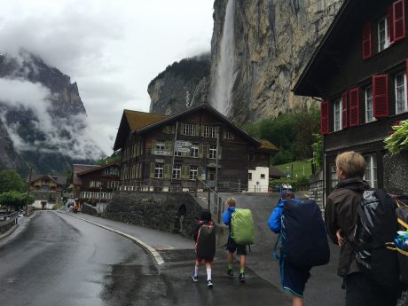
Waterfalls were tumbling off high cliffs above us and all around us. Below is a lush, green valley with few buildings. We walked in a light sprinkling of rain about one-third of a mile to find what would be our favorite accommodations so far, a really neat cabin in the Jungfrau Campground.

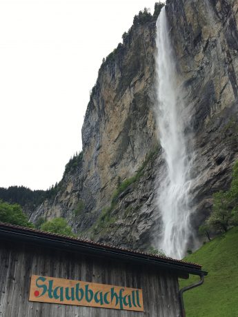
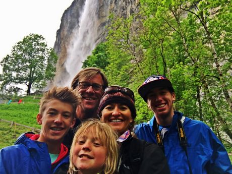
We got settled in our cabin, and then headed for a quick walk. We had been sitting in trains all day so wanted to stretch our legs and check out our new destination. We ventured to the nearby showstopper of a waterfall, Staubbach Falls. With a height of nearly 300 meters, Staubbach Falls is the second highest waterfall in Switzerland. It is one of 72 waterfalls in Lauterbrunnen Valley.

Staubbach Falls.
Staubbach Falls.
Staubbach Falls.
Family selfie in front of Staubbach Falls.

Did I mention how awesome our accommodations were?!! Check out the video I snapped on our first morning waking up. And enjoy the bird songs in the background:

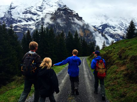
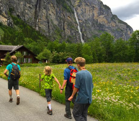
We woke up early in Lauterbrunnen because we had big plans, and wanted to get an early start. Today we would hike the Lauterbrunnen-Murren-Gimmelwald-Trummblebach Falls loop hike.

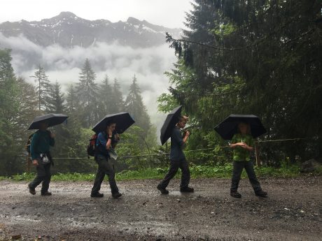
We’d do it without using any lifts, so it would be a big, long day. Why would you not take the tram lift up at the start in order to remove the several thousand feet of vertical uphill hiking, you ask? Well that is a good question! The reason is Jerry and I mistook meters for feet. What we thought would be a 1,000-foot vertical gain in the beginning of the hike was really 3,000+ feet. Oops. Thankfully we hike a lot with the boys in Wyoming, and they’re used to climbing lots of vertical feet. But, despite what our boys think, ours was an honest mistake!

Add to that it was raining when we started, so we had had on rain jackets, and each of us carried our own umbrella. Our sons are such troopers. And so is my husband. I am so blessed that to have a family of troopers, because today’s outing pretty much required that!

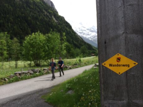
Here are some photos from the first part of our epic hike:

IMG_8486

IMG_8482

IMG_8484

IMG_8485

IMG_8481

IMG_8475

IMG_8523

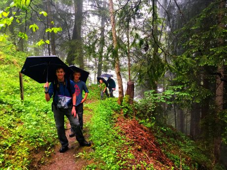
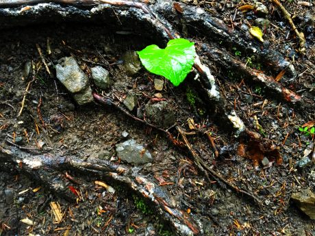
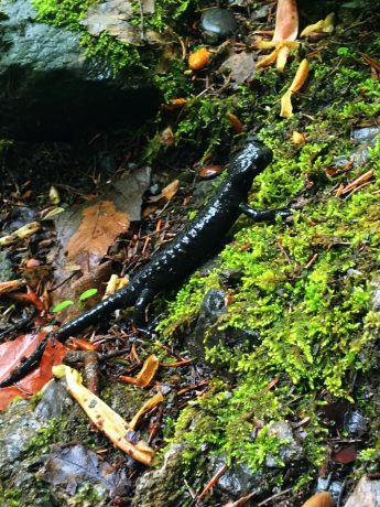
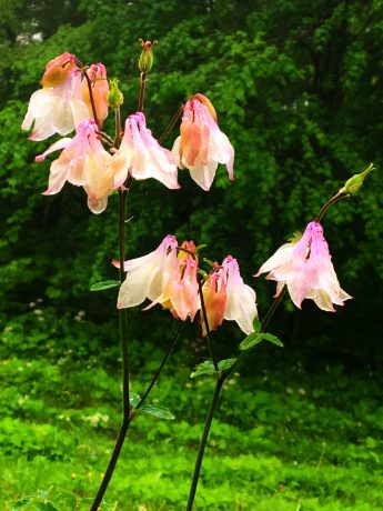
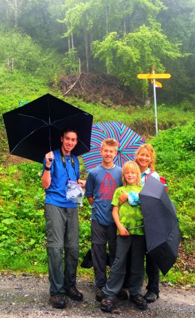
It was during the grunt of uphill through the lush and wet forest, when I was gasping for air and the miles of uphill were so never-ending that I realized that we had forget to convert meters to feet. Jerry and I would pay for this… We were certainly not winning parents-of-the-year honors this morning…

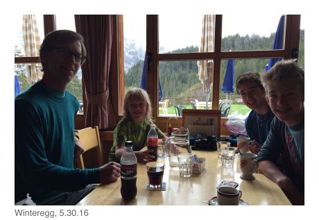
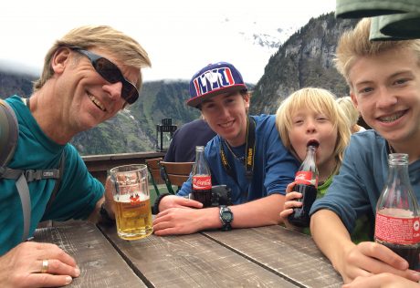
We had heard that Winteregg would be a stop we could make after the first five or six miles of hiking, and that we may even be able to enjoy some hot chocolate there. Thank God it was true.

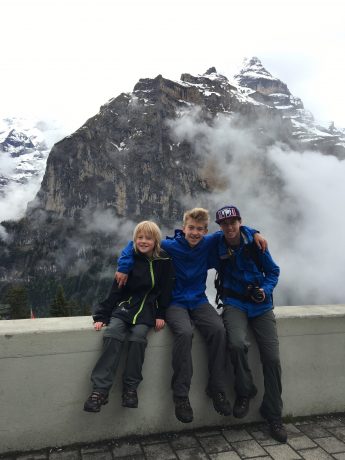
After about 2.5 hours of hiking, we spotted it and it just opened as we arrived. Jerry and I enjoyed coffees and the boys had hot chocolates.

My guys, getting a hard-earned rest and beverages from Winteregg, during our hike.

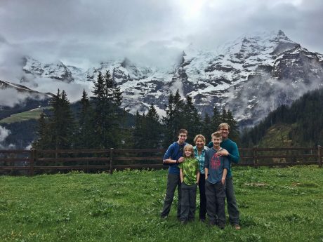
The woman who waited on us was so kind, she offered to take our photo outside under three giant mountains, whose tops were obscured by clouds but whose presence could still be felt. The mountains we stood under are the Eiger, Mönch, and Jungfrau.

Family photo.
Family photo.

After warming up and getting rested, we snarfed some special Swiss chocolate bars we brought. (We are now in love with Milka bars, and of course Toblerone, which are in abundance here.) We loved the next part of the hike becasue it was flat, and led us to the awesome – and car-less – town of Mürren.

Hiking from Winteregg to Mürren.

According to Wikipedia, Mürren is a traditional Walser mountain village in Bernese Oberland, Switzerland, at an elevation of 1,650 m (5,413 ft.) above sea level and unreachable by public road. Tourism is popular through the summer and winter; the village features a view of the three towering mountains: Eiger, Mönch, and Jungfrau. Mürren has a population of just 450, but has 2,000 hotel beds.

Our boys, sitting in front of Jungfrau in Mürren.

All we knew was that it was a beautiful town and soon, we could see it. And more importantly, soon we’d be eating at a restaurant there. By now the boys, and Jerry and I, were famished!

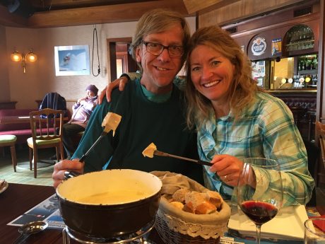
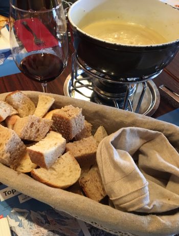
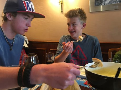
We decided on the Eiger Guesthouse for lunch, and it was an exceptionally good pick. Jerry and I shared cheese fondue and a basket full of fresh baked bread, along with a pint of beer for Jerry and a glass of red wine for me. The boys shared a pizza and also ate some of our fondue. Never has a meal hit the spot so well! Here are some photos:

OMG, we finally got to experience firsthand, Switzerland's cheese fondue. It was worth the wait! Incredibly yummy.
OMG, we finally got to experience firsthand, Switzerland’s cheese fondue. It was worth the wait! Incredibly yummy.

IMG_8515

IMG_8516

After a filling, delicious and long lunch break, we continued down the trail. Next stop: Gimmelwald, a smaller car-less village that Rick Steves recommends. Gimmelwald is a small village situated at about 4,000′ feet elevation.

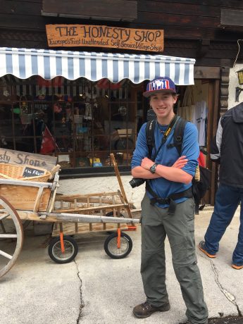
Gimmelwald also won us over. It’s another charming village. We especially loved their “Honesty Shop – Europe’s First Unattended Self-Service Village Shop.”

Wolf, in front of the Honesty Shop.

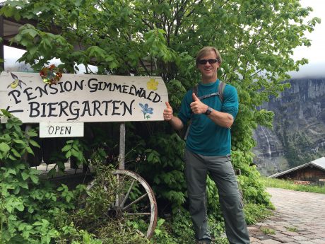
And, then, out of nowhere, we stumbled onto the Pension Gimmelwald Biergarten. Can this hike get any better??!! I don’t think so. It’s epic for so many reasons, most of which I’m including here. 🙂

Jerry, two thumbs up for the biergarten that was not a mirage, but a reality!
Biergarten refreshment.

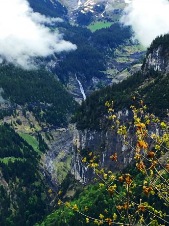
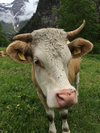
We loved this part of the hike, where we walked past big cows with their jangling bells around their neck, and views of the green lush valley below, toward which we were descending, and of course, waterfalls everywhere around us.

These cows with bells are everywhere, and you can hear their jangling bells as you hike.

See for yourself what this stretch of hike was like:

Jerry and the boys, marching at this point. :) About 2 miles left in the day's trek!
Jerry and the boys, marching at this point. 🙂 About 2 miles left in the day’s trek!
LOL. We think "wanderweg" means wandering. When this photo was taken by my husband of our two oldest sons, we had been wandering all right. All day long! :)
LOL. We think “wanderweg” means wandering. When this photo was taken by my husband of our two oldest sons, we had been wandering all right. All day long! 🙂

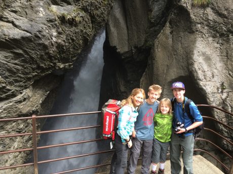
We continued down to the valley floor, and another 1.5 hours from there to one of the area’s most famous waterfalls, Trümmelbach Falls.

According to MySwitzerland.com, the Trümmelbach Falls are the world’s only glacier waterfalls that are accessible underground by lift, galleries, tunnels, paths and platforms. They alone carry the meltwater of the glaciers from the Jungfrau down to the valley – up to 20,000 liters of water per second. The water carries with it over 20,000 tons of boulders and scree per year and causes the entire mountain to shudder and make a thundering noise.

We paid to see what all the fuss is about, and it was worth it! Here’s a video:

The boys and I in front of Trümmelbach Falls.

When we got back to our cabin, we had hiked 16 miles, including 3,400′ of gain. We were all completely fulfilled and exhilarated, despite being worn out. It was such a fantastic day that included so many highlhights. I’ve tried to list most of them, but trust me when I say there are even more. I simply need to end this blog post so I can get a little shut-eye before we ride a train tomorrow to Zermatt, Switzerland.

Thank you for following along with us on this Epic Adventure. I hope you’ll stay tuned for our upcoming posts.

Next up: Zermatt, Switzerland (including the Gornergrat train ride and views of the Matterhorn and a report about another epic hike we’ll do in that region.)

If you’re interested, here are all of my previous blog posts about this Epic Europe Family Adventure so far:
• From Wyoming to the British Museum and Shakespeare’s The Taming of the Shrew in 24 hours
• Big Ben, River Thames, Tower of London and Ice Cream
• Munich Day 1: Glockenspiel, Deutsches Museum, Englischer Garten and Beirgarten
• Biking in the Bavarian Alps, Exploring Neuschwanstein Castle, Epic Beer & Food

Filed Under: Family, Frontier Life, Life and Leadership, National Parks, Travel & Tourism Tagged With: eiger, epic hiking, family adventure, fondue, gimmelwald, hiking, jungfrau, lauterbrunnen, monch, murren, staubbach fall, switzerland, switzerland hiking, trummelbach falls, waterfalls, winteregg

Hiking and Hunting For Treasure in Grand Staircase-Escalante National Monument

April 20, 2011 by Shelli

One of the many highlights of our week-long family camping trip in southwestern Utah was a hike to Calf Creek Falls in the Grand Staircase-Escalante National Monument.

Our sons at the start of the Lower Calf Creek Falls hike.

The Grand Staircase-Escalante National Monument, which was set aside as a national monument in 1996, contains 1.9 million acres of land in southern Utah. There are three main regions: the Grand Staircase, Kaiparowits Plateau, and the Canyons of the Escalante.

Family photo in front of Lower Calf Creek Falls.

Our trip started in Goblin Valley State Park. On Day Three of our trip, we were going to be traveling along the north boundary of Grand Staircase-Escalante on our way to Kodachrome State Park. Even though we were only traveling through the Escalante area, we wanted to experience it more intimately than simply driving through it, which is how we experienced it a few years ago.

After only brief investigation it became clear that we would be remiss – nuts, even – if we didn’t hike to Lower Calf Creek Falls. The hike is three miles one-way (6 miles roundtrip), and the reward for hikers is big: a 126-foot, beautiful waterfall, at the head of Lower Calf Creek Canyon, which plunges into a perfectly round green pool. Its upper tier fall, which isn’t visible from the base of Lower Calf Creek Falls, is 88 feet tall, making the waterfall’s total height 214 feet. Hikers who want to see the upper fall can scramble about a mile further up to catch a glimpse.

Lower Calf Creek Falls is glorious. The “ribbon-like” waterfall is outlined with green and yellow colors from algae growing on the sandstone, which thrives on the waterfall’s year-round flow.

My boys, all five of them, enjoying a picnic at the waterfall.

After a wonderful picnic near the waterfall, we had another adventure to tend to: To find a geocache that was reportedly in the vicinity. Our older sons, Wolf, 11 and Hayden, 9, and I scrambled above the trail in search for the treasure. After using our GPS to determine its location, and some fun exploring and mystery, we were successful in our “hunt.” It was very exciting! Finding the geocache marked our first official geocache find. And, I might add, our family is now hooked on geocaching.

We had big expectations for the hike, and our expectations were exceeded. Our almost-four-year-old son hiked the entire six miles with not too many complaints and after only a handful of bribes. His brothers, ages 11 and 9, were great “adventure leaders” on the hike.

Yeehaw! Our older sons, Wolf and Hayden, pose with the geocache they found.

I highly recommend this hike. The trail is wide and mostly packed dirt. It’s level and easy-going, beautiful, and includes 15 interpretive markers. A bonus are the pictographs hikers can glimpse on the massive, tall cliffs while hiking past interpretive marker #9.

Here’s a short video that shows you some of the scenery included in the Lower Calf Creek Falls hike, as well as a little bit of the geocaching adventure:

Stay tuned for upcoming blog posts about Kodachrome State Park and Coral Pink Sand Dunes.

Filed Under: Family, Frontier Life, National Parks, Travel & Tourism Tagged With: calf creek falls, family adventure, geocache, grand staircase-escalante, hiking, pictographs, utah, waterfalls

Thunderous waterfalls and granite giants

May 21, 2009 by Shelli

(Written May 17, 2009)
As I write this I’m in a tent in Yosemite National Park. When we step outside we have views of a thick, green, healthy forest of big pine trees dotted with dogwood, and views above of Half Dome, a granite behemoth that towers over Curry Village. If that all isn’t enough, we can hear a thunderous roaring waterfall… Yosemite Falls, as in the 2,425-feet-high tallest waterfall in North America, which is just down the way from us.

(Don’t tell anyone, but our tent is insulated and heated… electricity included… I’m plugged in right now as a matter of fact. We’d prefer people think we roughed it, but the truth is we’re not very bad off. Thanks to our friends at Delaware North, we have a comfy, warm refuge to retreat to following two days of hard hiking and exploring.)

Yosemite's Curry (Tent) Village. Not really roughing it, if I must be honest...

My dear friend, Sabrina Thoren, is on this trip with me. Yosemite National Park was a our Plan B. Our Plan A had been to take a backpacking trip to the remote Havasu Falls, in the Grand Canyon West region. We were going to experience a little adventure and soaking and relaxing as a belated celebration for our turning 40. (As it is Sabrina is 43 already, so this trip was long overdue) Havasu Falls is on both of our bucket lists. But one-and-a-half weeks ago, we got a call from the Havasupai Tribe informing us all access to the area was closed until June 1. Our flights into Las Vegas, long booked, were nonrefundable.

We soon discovered that not only is Yosemite a Plan A, but it's a true bucket list trip. It is truly magnificent and was an epic trip.

Ironically, at the time I was helping lead development of several national park sites, one of which is myYosemitePark.com. While working with the Yosemite-based writer, reviewing and compiling content, and selecting photos and videos to feature on the site, I was beyond inspired. Yosemite remained one of the national park wonders I had yet to visit.

At the same time, I was furiously looking for a Plan B based out of Las Vegas that would be “epic” and as memorable as Havasu Falls would have been. Zion and Grand Canyon, two epic alternatives, were not options since I only recently returned from great adventures in those regions.

Surfing the net one evening in bed four nights before our flights were to depart, after learning we could extend our flights to SFO for under a hundred bucks, I texted Sabrina (who lives next door) the following message: “How about Yosemite for a Plan B?” Swiftly I got a response. “Wow! Go for it. I’m in.”

And just like that we had a Plan B. These two “country bumpkins” (small town Wyoming girls) would be going to California’s Yosemite National Park. Turns out I’d get to see firsthand what all the fuss is about when it comes to Yosemite. And, most importantly, turns out our Plan B has turned out better than probably our Plan A would have been. If it was a waterfall we wanted, we’d get lots of them, and not just any waterfalls…

Yosemite National Park can best be described in one word: MAGNIFICENT. If I must use a few more words, they would be spectacular, giant waterfalls, phenomenal, giant granite formations, awesome, giant sequoias, magnificent and epic. This is truly an amazing place. Its beauty is astounding.

Half Dome.
Half Dome.

By the time we flew into San Francisco and got lost and took several extra hours to find our way to Yosemite National Park, we had taken to referring to ourselves “country bumpkins #1 and #2.” The name was fitting, especially as we stumbled into Yosemite’s Curry Village looking for Tent #942, long after dark.

After a restful night in the tent, we awoke to a clear sky, got coffee from the Coffee Corner and walked a couple of miles to Yosemite Lodge, where we would catch the Hiker Shuttle to Glacier Point. An admitted coffee junkie, who needs coffee when you have views like Yosemite’s? We were greeted by Half Dome towering over a thick green forest surrounding our tent. Along our path to the shuttle pick-up, we enjoyed views of North America’s tallest waterfall, Yosemite Falls. Yosemite Falls, at 2,425 feet tall, is a stunning sight and provides a backdrop for much of the Yosemite Village area.

Near start of our hike to Panorama point and the Mist Trail.

After an hour-long, educational shuttle trip, we were delivered to Glacier Point, where our jaws hung open at the view that greeted us. There before us the Yosemite Valley unfolded, complete with Half Dome towering and framing the left end of the view, and a roaring, white Nevada and Vernal Falls framing the right. Linking it all was a dense, green, healthy forest of endless trees. After being adequately stunned and inspired, we headed down the trail to Panorama Point and the Mist Trail.

It was a long hike, but a pretty reasonable one, as far as effort goes. After about two or three miles, you cross a small bridge over the under-promoted-but-still-beautiful Illoluette Falls, before continuing on for the main prizes, Nevada and Vernal Falls.

Along the raging Merced River.

The 9-mile trail is mostly downhill, except for a mile-and-a-half stretch right before your first encounter with the impressive, roaring, huge Nevada Falls.

The volume of water running off forming Nevada Falls is astounding.

Check out this sampler of the scenery hikers enjoy:


Nevada Falls blew us away. The volume of water and its force and loud roar is overwhelming. Photos and videos don’t do it justice, but certainly they do better than mere words. We could hear the roar of the waterfalls, and also feel them under foot as we approached on the trail. You really have to check these out firsthand. You will be better for it. I know the sights and sounds will remain with me forever, and I will recall them in the coming days and weeks and be inspired each time.

By the time we were done taking in Nevada Fall, we were overheated. It was about 85 degrees, if not more, and we had been hiking in the hot sun for a couple of hours.

We kept hearing people mention Mist Trail and Vernal Falls. As we made our way down the trail between Nevada and Vernal Falls, the people hiking up that we met on the trail were soaking wet – literally dripping wet, hair and all. We couldn’t wait to see what the Mist Trail section would bring, as we were hot and looking forward to some relief and cooling off.

At Vernal Falls, people laid out sunning on the big slab of rock that is separated (thank goodness) from the river and waterfall’s upper brink by a metal fence.

The brink of Vernal Falls.

Boy, were we hot. Sabrina was getting a little tired of all the media capture and wanting to get “misted” like the upward hikers we were meeting on the trail. I was eager as well.

Soon after we finally got a great vantage of Vernal Falls and started descending a stone staircase-like trail that was being misted over by the nearby rush of Vernal Falls. The view and sound and mist of Vernal Falls was more than enough to satisfy, but throw in a rainbow cutting through the mist and this was a major thrill for us.


We packed all the gadgets and cameras away except for the one waterproof camera and off we went. Eager to get wet but (apparently) not too wet, Sabrina left me in the Mist and I lolly-gagged taking videos and pictures and enjoying both the awesome, cold, refreshing shower Vernal Falls provided me and the spectacular scene… a rushing waterfall, rainbow and mist spraying a cloud over the nearby trail and its visitors.

Country Bumpkin in the Mist.

From there, we hiked another mile or two to the bottom, ending at Happy Isles, where a shuttle awaited, but we didn’t take. (Much to Sabrina’s regrets. I bribed her to walk the remaining flat mile to Curry Village and it only cost me a fudgecicle.)

It was a glorious day in God’s country. Like so many of our national park wonders, Yosemite National Park gave and gave and gave. Our first day, and time, in Yosemite National Park was nothing short of epic. The sights were stunning, the sounds were exhilarating and the adventure was epic. It was a fulfilling and rewarding day in California’s star national park.

We returned to our tent village, where we enjoyed a hot shower, great meal and restful night, where I’m currently entering this post. : >

Here is a compressed video clip that captures the hike from Glacier Point to Panorama Point to Mist Trail:

If interested, here’s another post about Giant Sequoias, and other stunning Yosemite Park sights.
If you’d like to see more images from Yosemite National Park, here is a link to my Flickr Photostream of the whole Yosemite trip, including waterfalls, Half Dome, Yosemite Valley, Mariposa Grove (including the 27-foot-wide Grizzly Giant Sequoia).

Or, here’s a link to another post that covers a handful of other stunning Yosemite sites.

BTW, when I’m not enjoying our national parks in the West, I’m most likely working on promoting them on behalf of Active Interest Media.

To get in on all fun, start here. We want to share tips and media about our favorite national park wonders in the West and help others have a vacation of a lifetime like my recent one in Yosemite.

P. S. Thank you very much to my good friend, Mike Lilygren (and his business partners, Cade Maestas and Brendon Weaver) of Bridge Outdoors, who outfitted me with enough portable power to charge an army’s media gadgets.

Filed Under: National Parks, Travel & Tourism Tagged With: granite, half dome, mountains, national park, nevada fall, travel, vacation, vernal fall, waterfalls, yosemite, yosemite fall, yosemite national park

Primary Sidebar

About Shelli

Hi. My name is Shelli Johnson. I live on the frontier in Lander, Wyoming. I’m a wife, a mother, an entrepreneur, certified life/leadership coach, wellness coach, keynote presenter and inspired speaker, leadership development facilitator, personal development strategist, writer and adventure guide. This blog mostly includes stories about adventures and travel, but other passions are reading/books, technology, fitness, nutrition, and national parks, so you’ll find a wide range of articles here. I am founder of Yellowstone Journal and YellowstonePark.com, and NationalParkTrips.com, which was my first business. My current company, Epic Life Inc., is in its 7th year, and going gangbusters. If you’re interested in learning more about my current work, I hope you’ll jump over there and learn more about that. I have a more personal blog, more directly related to life and living and leadership, at YourEpicLife.com/blog. I’d love it if you’d also check out that collection of my writings. Thank you for stopping by! Finally, if you’d like to connect with me directly, please email me if you’d like to connect.

  • Facebook
  • Instagram
  • LinkedIn
  • Twitter

Subscribe For Email Updates

Check your inbox or spam folder to confirm your subscription.

Archives

Links

  • Your Epic Life
Copyright © 2025 · Have Media Will Travel